Geotic Inc.
GeoticGraph

|


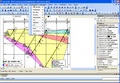
GeoticGraph has all the features and flexibility you need to create quality section drawings and much more. Drawings created by GeoticGraph are compatible with GeoticCAD, AutoCAD and Micro Station.
GeoticGraph has the following features:
• User-friendly and intuitive Windows environment (Windows XP to Windows 7)
• Trilingual (English, French and Spanish)
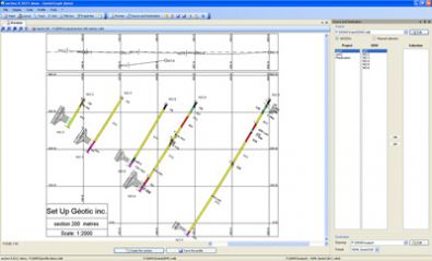
• Graphic symbols for structural elements (fault, schitosity, joint, etc.)
• Optimized to create 3D VDML GeoticCAD drawings
• High quality drawings
• Features can be adapted to all requirements
• Creation of 3D drawings in DWG and DGN format (AutoCAD and Micro Station software not required)
• Creation of 2D drawing formats (JPG, TIF, PNG, EMF, GIF, BMP, WMF, TGA)
• Colour codes relating to core descriptions
• Possibility of including graphs for geophysics and assaying
• Legend texts for creating GeoticCAD legends
• Integration of drilling core photos
• Planning of 3D drilling allowing for standard deviation
• Export of information into CSV table
• Total control over data presentation including bar charts
• Section creation wizard
• User-friendly and intuitive Windows environment (Windows XP to Windows 7)
• Trilingual (English, French and Spanish)
• Graphic symbols for structural elements (fault, schitosity, joint, etc.)
• Optimized to create 3D VDML GeoticCAD drawings
• High quality drawings
• Features can be adapted to all requirements
• Creation of 3D drawings in DWG and DGN format (AutoCAD and Micro Station software not required)
• Creation of 2D drawing formats (JPG, TIF, PNG, EMF, GIF, BMP, WMF, TGA)
• Colour codes relating to core descriptions
• Possibility of including graphs for geophysics and assaying
• Legend texts for creating GeoticCAD legends
• Integration of drilling core photos
• Planning of 3D drilling allowing for standard deviation
• Export of information into CSV table
• Total control over data presentation including bar charts
• Section creation wizard
System Requirements:
• Microsoft Windows XP, Windows Vista, or Windows 7
• 1.5 GHz, single-core minimum ~ Recommended: Intel 2.0 GHz dual-core or better
• 1 GB RAM minimum ~ Recommended: 2.0 GB or more
• Display dimensions of 1024x768 or greater
User's FAQ
Can I install the software on one or several computers?
- You can install on as many stations as you like, the software is activated via USB key.
What formats can GeoticGraph generate?
- DWG (Autocad 12 to 2007), DXF, PDF, DGN, Jpeg, Tiff, ...)
Does Geotic offer free updates?
- Updates are included in the annual leasing.