AIRVU UAV Solutions
Aerial Inspection and Mapping Services from AIRVU
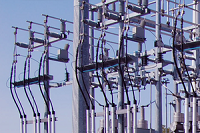
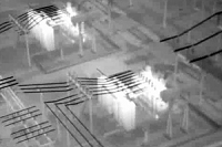
AirVU combines the latest UAV technology with mapping and design software to bring new possibilities to the engineering field. Through the use of infrared camera, AirVU’s Aeryon Skyranger sUAS (small unmanned aerial system) can survey electrical utility stations, locating bad electrical connections and asset serial numbers from a distance.
 |
 |
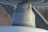 |
| Survey electrical utility stations | Locate bad electrical connections using infrared images and video | Locate, audit, or confirm serial numbers from a distance |
Source: http://www.airvu.ca/#casestudies-1
Magazine
No information