Atacama 3
Introduction
Jun 16, 2020
The Atacama 3 property is owned 100% by Atacama Resources and located in the Kirkland Lake area of northeastern Ontario. Kirkland Lake is one of Canada’s most prolific gold mining areas, accounting for about, 25 million ounces of bullion produced from seven mines along the “mile of gold” with an additional 11 million ounces produced by Kerr Addison Mine on the Larder Lake- Cadillac Break to the east. When all the past producing mines of the area are considered, the aggregate production totals 37.63 million ounces of gold. The Atacama 3 property is located 4 kilometers southeast of the Macassa headframe of Kirkland Lake Gold and 3 kilometers east of the Swastika Mine in northeastern Ontario.
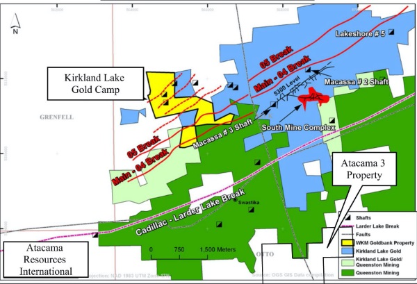
Figure 1: General Location of the Atacama Eby Otto Property in relation to the Kirkland Lake Gold Mining Area
The Atacama 3 property consists of 3 claim groups comprising:
Atacama 1: 12 leased claims
Atacama 2: 13 units
Atacama 3: 17 units
All in north central Otto and Eby Townships.
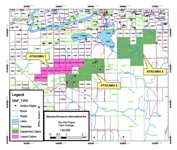
Figure 2: Location of the Claim Groups in Eby and Otto Townships
General Geology
The Atacama 3 property is situated within the Larder Lake Group (Lower Tisdale) assemblage of volcanic rocks approximately 1.5km south of the Larder Lake-Cadillac Break. Previous mapping drilling has identified that a major alteration zone consisting of silicification and weak albitization accompanied by pyrite, occurs over a strike length of 1,000m and a width of 200m along the Eby-Otto fault which is a subsidiary of the Larder Lake Break. This style of alteration is similar to that found in the Kirkland gold mines to the north. The presence of mineralized graphitic and cherty interflow horizons within the mafic volcanic flow package is interesting because it suggests proximity to an Archean exhalative basinal environment that may potentially host VMS (volcanogenic massive sulphide) style mineralization.
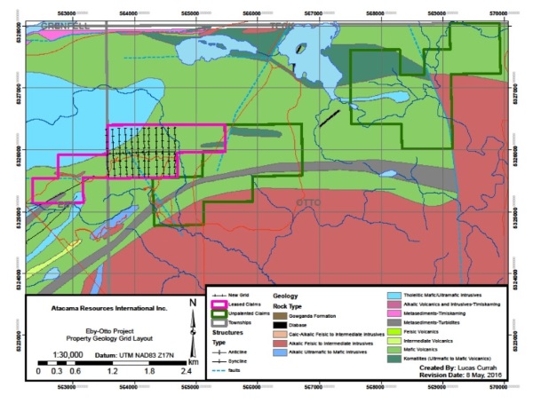
Figure 3: Geology of the Atacama P3 property
Recent Work
A total of 18 km of cut lines, Induced Polarization, Magnetic and VLF-EM surveys were recently completed on the Atacama 3 property. Cut lines were read using Induced Polarization, Magnetics and VLF EM surveys, in a north-south direction at 100m line spacings. The purpose of the surveys was to detect undiscovered gold and base metal environments. Three main IP Chargeability horizons were identified which are both iron formations and graphitic sediment interflow units. Zinc mineralization has been observed on the upper graphitic horizon. A total of 8 channel samples (average length 1 meter) were taken in this vicinity that showed greater than 1% Zinc with a high of greater than 4% Zinc and associated with anomalous values in Gold, Silver, Copper, Lead, Arsenic, and Cobalt. A possible carbonate altered volcanic unit may parallel the graphitic sediments and this target is favourable for drill follow-up for gold mineralization. The geophysical surveys also identified a major N-S trending structure that transects the property and extends north through the main Kirkland Lake gold mineralized trend. This structure may have acted as a conduit for gold mineralizing solutions and will also be investigated for its gold hosting potential. Ground follow-up on the geophysical surveys will be done next Spring.
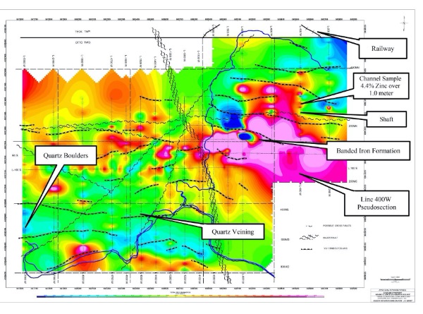
Figure 4: Atacama 3 Property showing significant features on the property on a magnetic background. Squiggle lines are presumed faults, dashed lines are VLF-EM conductive zones. Zinc values over 4% are indicated by arrow and a Induced Polarization pseudo-section (Figure 5 below) shows the zinc values in relation to a chargeability high indicating sulphide content and a resistivity low indicating a conductive zone.
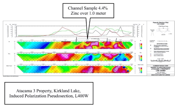
Figure 5: Atacama 3 Pseudosection from Induced Polarization Survey showing relative location of Zinc Occurrence.
Source: https://acrlintl.com/properties/atacama-3/