Côté Gold Project, Ontario
Mar 27, 2014
 Location
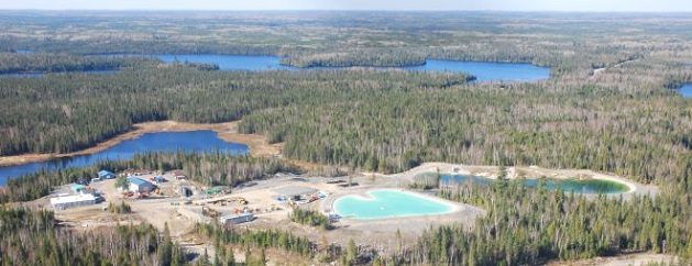
IAMGOLD is assessing the potential to construct and operate a new open pit gold mine on the Project property. Open pit mining operations are estimated to occur at a rate of approximately 60,000 tonnes per day of ore production. The preliminary site layout proposes to install the necessary mine-related facilities in close proximity to the open pit.
The major Project components are expected to include:
• an open pit;
• an ore processing plant;
• a maintenance garage, fuel and lube facility, warehouse and administration complex;
• a construction and operations accommodations complex;
• an explosives manufacturing and storage facility (emulsion plant);
• various stockpiles (low-grade ore, overburden and mine rock (MRA));
• aggregate extraction with crushing and screening plants;
• a tailings management facility (TMF);
• on-site access roads and pipelines, power infrastructure and fuel storage facilities;
• potable and process water treatment facilities;
• domestic and industrial solid waste handling facilities (landfill);
• water management facilities and drainage works, including watercourse realignments; and
• a transmission line and related infrastructure.
Location
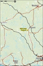
The Côté Gold Project is located in the Chester and Neville Townships, District of Sudbury, in northeastern Ontario. It is approximately 20 km southwest of Gogama, 130 km southwest of Timmins, and 200 km northwest of Sudbury, roughly 5 km west of Highway 144.
The Project area is characterized by gentle hills, forests, lakes and rivers. The Project area is located on two subwatersheds, the Mollie River system and the Mesomikenda River system. Additionally, the intercontinental watershed divide is located south of the Project property, with the nearest boundary located southwest and more than 3.5 km from the proposed open pit location. Land use in the area consists of recreational activities by locals and tourists, including fishing, camping and hunting. It is also extensively used for sustainable harvesting of timber.
History
IAMGOLD acquired Trelawney Mining and Exploration Inc. in 2012. Trelawney had carried out exploration activities at the Project site since 2009.
Exploration activities have been ongoing in the area since the early 1900s by various companies and government agencies. More concentrated mineral exploration efforts were conducted in the early 1940s and from the early 1970s to about 1990.
Since its discovery in 2010, extensive diamond drilling activities have been undertaken to delineate the Côté Gold deposit.
Geology
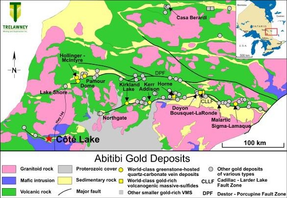
The deposit is underlain by rocks of the Swayze greenstone belt representing the southwestern extension of the Abitibi greenstone belt of the Superior Province. The Swayze belt contains a diversity of extrusive and intrusive igneous rock types ranging from ultramafic through felsic compositions, as well as, both chemical and clastic sedimentary rocks. The Swayze greenstone belt underwent a complex and protracted structural history of polyphase folding, development of multiple foliations, ductile high-strain zones, and late brittle faulting.
Chester Township overlies a narrow greenstone belt assemblage which separates the Kenogamissi granitoid complex to the south. A portion of the northern edge of the Ramsey-Algoma granitoid complex is called the Chester Granitoid Complex (CGC). The Côté Lake deposit is underlain by calc-alkalic pyroclastic metavolcanics of felsic to intermediate composition (Chester Group), felsic to intermediate granitoid intrusive rocks, namely tonalite, trondhjemite, granodiorite, and diorite of the CGC and related migmatites. The granitoid rocks are very heterogeneous reflecting a number of primary igneous intrusive phases, migmatization and assimilation of older country rocks and local rafts and screens of the intruded supracrustal lithologies.
Mineralization
The Côté Gold Project deposit consists of low to moderate grade gold +/- copper mineralization which is associated with brecciated intermediate to felsic, and locally mafic intrusive rocks. The nature of the alteration and mineralization suggests a porphyry-style deposit. Regionally, two different types of gold mineralization are recognized. The historically important mineralization can be termed quartz vein and fracture associated, while the more recent discovery of the Côté Lake deposit represents a large gold mineralized system associated with altered and brecciated intrusive rocks interpreted as an Archean gold porphyry deposit. The extent and limits of the mineralized volume hosting the Côté Lake deposit are not yet defined but currently it has an east-northeast extent of at least 1200 m, a width of 100 m to 300 m, and a depth extent of more than 500 m. The mineralized zone remains open along strike and at depth. Drilling supports an emerging understanding of the geology where a core breccia mass within diorite is surrounded by granodiorite. A gold-mineralizing hydrothermal system has overprinted the volume of magmatically brecciated rock and developed as yet poorly defined zones of propylitic and potassic alteration.
Mineral Resource
An updated Mineral Resource estimate was disclosed on October 4, 2012 incorporating assay results from an additional 79 holes (44,856m) since the February 24, 2012 estimate announced by Trelawney Mining & Exploration Inc. The mineral resource estimate has been carried out by Roscoe Postle Associates Inc. ("RPA") and reported in accordance with National Instrument 43-101 requirements and CIM Estimation Best Practice Guidelines. The resource estimate was prepared by RPA Associate Principal Geologist Jamie Lavigne, P.Geo with geostatistical input and verification provided by Mohan Srivastava, P.Geo. An updated NI 43-101 Technical Report will be posted on SEDAR at www.sedar.com on or before October 24, 2012.
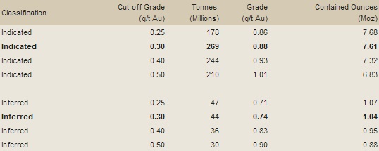
The estimate reports an Indicated Mineral Resource of 131 million tonnes averaging 0.84 g/t for contained gold of 3.56 million ounces and an Inferred Mineral Resource of 165 million tonnes averaging 0.88 g/t for 4.66 million ounces of contained gold. Table 1 presents the Mineral Resource at the 0.3 g/t Au cut-off grade and at several additional cut-off grades for comparison purposes. The current Mineral Resource represents a 274% increase in Indicated Resources from the previous estimate as reported by Trelawney, also based on a cut-off grade of 0.3 g/t Au.
A preliminary open pit optimization algorithm was run on the estimated grade block model to constrain the resource and to support the CIM requirement that Mineral Resources have reasonable prospects for economic extraction. The resource estimate assumes a long term gold price of US$1600/ounce. All production costs and technical parameters assumed for the new estimate are more conservative than parameters used for the prior resource estimate. Only mineralization contained within the preliminary pit shell has been included in the resource estimate.
Table 1: CÔTÉ GOLD PROJECT MINERAL RESOURCE ESTIMATE
October 4, 2012
Notes:
1. CIM Definition Standards were followed for classification of Mineral Resources.
2. Mineral Resources are estimated at a cut-off grade of 0.30 g/t Au.
3. Mineral Resources are estimated using a gold price of US$1,600 per ounce and metallurgical recovery of 93.5%.
4. High grade assays are capped at 15 g/t Au and 20 g/t Au depending on sub-domain.
5. Bulk density of 2.71 t/m3 was used for tonalite and breccia and 2.79 t/m3 was used for diorite.
6. The Mineral Resource Estimate is constrained within a Whittle Pit shell using assumed costs and the above noted gold recovery and gold price.
7. Mineral Resources are not Mineral Reserves and do yet have demonstrated economic viability, but are deemed to have a reasonable prospect of economic extraction.
8. Numbers may not add due to rounding.
9. Mineral Resources are reported on a 100% basis; IAMGOLD has a 92.5% average attributable ownership of this project.
Source: http://www.iamgold.com/English/Operations/Development-Projects/Cote-Lake-Ontario/Overview/default.aspx
