Northern Superior Resources Inc.
Croteau Est Gold Property
 Northern Superior’s 100% owned Croteau Est gold property is host to an easily accessible, shear-zone hosted gold deposit, discovered by the company in 2011. The deposit currently has a defined resource of 640,000 ounces grading 1.7 g/t Au, and remains open at depth and along strike. Croteau Est also benefits from its accessibility and location within the historically important Chapais-Chibougamau mineral exploration and mining camp, west - central Québec.
The property is situated in one of the more historically important mineral exploration and mining camps in Québec, with tremendous infrastructure and logistical support available from three local communities.
Location
- The Croteau Est gold property is centered 28km northeast of Chapais, and 17km northwest of Chibougamau within the Barlow and McKenzie townships in west-central Québec (Figure 1).
- The property is easily accessible all year-round and is in close proximity to an airport, a railway and the hydro grid.
- Croteau Est is situated within the Chapais-Chibougamau mining camp, which has produced 1,050 mt of gold at an average grade of 1.85 g/t Au since 1949.
- The region is currently undergoing an exploration-mining renaissance, with renewed interest fuelled by additional gold discoveries at Windfall Lake (Osisko Mining), Fancamp-Embry (Alexandria Minerals Corporation), Chevrier (Genesis Metals) and Barry (Metanor Resources): to name but a few.
Property Size Land Position and Ownership
Croteau-Est is 100% owned by Northern Superior Resources and consists of a contiguous block of 237 claims that encompass an area of approximately 12,454 hectares (Figure 1).

Figure 1:Location, Croteau Est gold property.

Figure 2:Revised long section through the CBSZ gold deposit indicating nine ore shoots of mineable grade (> 2 g/t Au) and width (> 5 m true width). The deposit is open both along strike to the west and to the east, and is open at depth.
The property already has an inferred resource defined of 640,000 gold, with several additional exploration targets identified.
Mineralization Potential
Although gold was first discovered in the Chapais-Chibougamau district as early as 1903, no permanent development took place until 1949 when economic copper deposits were discovered near Chapais. And although having begun as a copper mining camp, the Chibougamau-Chapais district has also been a major past producer of gold. Since its beginning, this camp was produced some 1,050Mt of gold at an average grade of 1.85 g/t Au.
Within the Chapais-Chibougamau camp there is a distinct variation in the average gold, silver and copper grades between various types of deposits in the district, which is a product of the various ore generating systems that have evolved over time.
The most important gold mineralizing event in the camp coincides with the onset of the Kenoran Orogeny (ca. 2700Ma) which resulted in a major series of east-west trending faults and shear zones that acted as a precursor for a major gold mineralizing episode. A number of deposits in the region (e.g. Cooke, Norbeau, Gwillim, Joe Mann) are hosted by such east-west structures. The spatial relationship between east-west trending shear zones and northeast trending fault systems has also been shown to be a possible mechanism for generating added dilatancy during a late Kenoran gold mineralizing phase.
These are typically lode gold deposits associated with shear zones showing characteristic advanced argillic (carbonate-ankerite-sericite-pyrite) alteration with the major gold mineralizing episode occurring late in the deformation sequence. The deposits bear a strong resemblance to other Archean lode gold hosted deposits elsewhere in the Abitibi Subprovince. The veins are mostly auriferous with, or without economic grades of copper. Gold occurs as a visible phase or as microscopic grains associated with pyrite and chalcopyrite. Most of these deposits are hosted within mafic sills.
A later, post-Kenoran shear system controlled the emplacement of the last major phase of gold mineralization in the district characterized by stratiform ultramafic intrusions of the Lac Doré Complex. Shear zones associated with the post-Kenoran Grenville Orogeny consist of southwest trending, northerly dipping, left lateral oblique dip slip shears that host numerous copper-gold deposits in the Chapais-Chibougamau district.
Croteau Est: Blue Sky Potential
Within the property, there are at least three other areas that share similar structural features to those observed at the gold-bearing CBSZ. Prospecting, reverse circulation and core drill programs have demonstrated that gold mineralization occurs within the vicinity of three of these areas (Trench 101; Area #5; South of the CBSZ). Furthermore, the presence of porphyry dikes and intersecting north-east to south-west faults and east-west deformation zones suggests similar structural and lithological conditions to those observed at the auriferous CBSZ: underlining the potential for gold mineralization across the property and not just within the CBSZ.
Croteau Est: Croteau Bouchard Shear Zone
Several key findings from drill programs completed within the CBSZ that are shown in the new longitudinal section (Figure 2) clearly demonstrate that a significant expansion in the growth of the current resource is anticipated (see Northern Superior Resources press release: January 14, 2016).
Key Findings
- Expansion of the deposit strike from 550 m to 750 m (east to west), and expansion of the resource from a previous vertical depth of 350 m to 425 m depth, with the continuation of mineralized intercepts to 575 m vertical depth.
-
Defining that gold mineralization associated with this deposit:
- Extends from surface and is open at depth; and is further
- Open along strike, both to the east and to the west
-
Defining no less than nine discrete ore shoots within the deposit that plunge at a shallow angle (20°-25°) towards the east; previous resource model defined only two ore shoots:
- Ore shoots are of mineable grade (> 2 g/t Au) and width (> 5 m true width).
-
Strategically changing the drill orientation from south to north to north to south during the 2017 Phase II and Phase III drill programs resulted in:
- Delineation of multiple ore lenses or shoots in a single drill hole compared to historic holes; and
- The overall number of significant assays per drill hole being much higher amongst the Phase II and III drill holes (109 values) compared to historic holes (29 values)(see Northern Superior Resources press release, February 20, 2018).
-
Coarse anhedral visible gold (Photo Panel 1) was noted in several holes during the Phase II and III drilling, with the results of 6,441 split core samples submitted for assay returning results:
- That encompassed high grade gold hosted by quartz veins as in drill holes CRO17-111 (705 g/t Au/ 0.5 m); CRO17-94 (56.4 g/t Au/ 1.0 m) + 14.6 g/t Au/ 1.0 m); CRO17-95 (60.4 g/t Au/ 0.9 m); CRO17-96 (72.9 g/t Au/ 0.7 m); CRO17-98 (39.9 g/t Au/ 1.05 m); CRO-17-107 (19.5 g/t Au/ 1.0 m); CRO17-108 (28.5 g/t Au/ 1.35 m); to
-
Wide intervals of lower grade mineralization associated with shearing and so-called “flat dipping” or horizontal quartz veins that were largely undetected by historic drill holes owing to their orientation that returned assays on the order of 1.19 g/t Au/ 47.0 m (CRO17-104); 1.47 g/t Au/ 31.85 m (CRO17-96); and 0.92 g/t Au/ 51.0 m (CRO17-99) (see Northern Superior Resources press releases: November 13, 2017; January 10, 2018).

Figure 3:Regional geology of the Abitibi sub-province (from Avery 2014).

Figure 4:The regional geology of the Chapais-Chibougamau district (from Avery 2014).
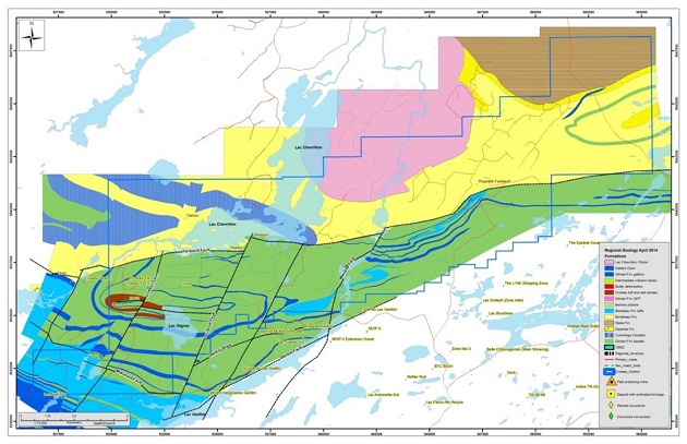
Figure 5:Croteau Est property geology (Avery, 2014).

Figure 6:Section facing south, through the 2018 3D geological model for Croteau Est, with the drill traces, vein domains and various dykes modelled (NSR press release dated May 23, 2018).

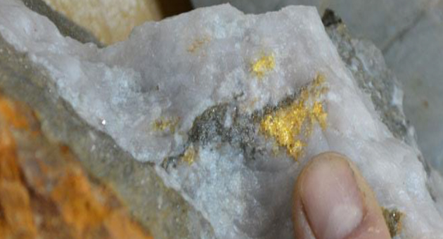
Photo Panel 1:
Examples of irregular clusters of course anhedral visible gold, observed at three different levels within the CBSZ: emphasizes continuation of the mineralization from surface to depth.
Recent Work Programs
In 2017 Northern Superior Resources completed a three-phase drill program at Croteau, with intention of establishing a more refined geological and structural model for the CBSZ deposit through televiewer surveys and core drilling. The 2017 core drill programs were completed on schedule (Q4-2017), on budget and succeeded in achieving the goals set.
A new geological model was constructed based on 81 drill holes (28,524.5 m of drilling) 2011-2017 drilling. This is an important increase in data points, compared with those used to create the original geological model, which was based on only 58 drill holes (19,418 m of drilling).
Next Steps
Northern Superior Resources plans to test extensions of mineralization from the CBSZ, in particular targeting eastward plunging high-grade ore shoots identified from the 2017 drill program These shoots plunge towards an intersection between the CBSZ and a north-south trending deformation zone, which may host additional mineralization. With an opportunity now clearly defined to further grow this resource, a sustained core drill program is required. The Company is currently seeking a strategic partner to assist on moving exploration forward on the property.
Source: http://www.nsuperior.com/Projects/croteau-est.aspx

|