Aurelius Minerals Inc.
Mikwam Property

Size: 968 hectares, 9 legacy claims consisting of 69 Cell Claims including 29 Single Cell Mining Claims and 40 Boundary Cell Mining Claims
Target: Quartz-carbonate vein system
Access: Logging roads
Location:
- Abitibi greenstone belt, on the Casa Berardi deformation zone
- 160 km northeast of Timmins, ON in the Larder Lake Mining Division
- Surrounded by Detour Gold’s Burntbush property
Project Highlights
In the second half of 2016, Detour staked its Burntbush project which now, completely surrounds the Mikwam property. In its September 15, 2016 news release, Detour noted that Aurelius’ Mikwam Property is the only portion of the Burntbush land which contains a gold resource.
Resource
Mikwam contains an NI 43-101 estimated inferred resource of 1.81 million tonnes grading 2.34 grams per tonne (g/t) gold, containing 136,000 ounces of gold.
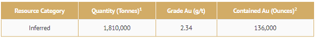
Reported cut-off grade of 1.00 g/t Au. Mineral resources are not mineral reserves and do not have demonstrated economic viability.
(1) Tonnes have been rounded to the nearest 10,000. Grade has been rounded to two significant digits.
(2) Rounded to the nearest 1,000.
Geology
The Mikwam Property lies in the Harricana-Turgeon belt within the northern portion of the Abitibi greenstone belt of the Superior Province of the Canadian Shield. The Harricana-Turgeon belt hosts polymetallic deposits and several well-known gold deposits such as the Eagle mine, the Casa-Berardi mine and the Detour mine.
The Harricana-Turgeon Belt consists of the granitic intrusions, surrounded by felsic to mafic metavolcanic rocks, metasedimentary rocks and minor mafic to ultramafic intrusions. The Mistawak Batholith is the largest of the granitic intrusions and is composed of quartz monzonite and granodiorite.
The metavolcanic and metasedimentary rocks have undergone low pressure, contact and regional metamorphism of greenschist- and lower amphibolite-facies. The metamorphic event occurred between 2.6 and 2.7 Ga.
The Casa Berardi Deformation Zone (CBDZ) is a major, subvertical regional structure 4 to 6 km wide and at least 60 km in length. The CBDZ is crosscut at low angle by the Casa Berardi fault which is a brittle, schistose zone 0.5 to 5 m thick.
Mineralization
Recent exploration has concentrated on the A8 3200 vein system which consists of a zone of quartz flooding, silicification, and sulphidization which lies at or near the contact of chloritic iron formation and either argillite or conglomerate. Medium to coarse grained cubic pyrite and coarse grained arsenopyrite within a highly sericitized, quartz flooded matrix comprises the bulk of the mineralized gold zone. The best gold values tend to be associated with pyrite containing vugs.
The A8 3200 vein system strikes approximately eastwest, and dips steeply north however, it appears to change direction to strike ~130° near the middle of the zones due to folding. A steep moderate westerly plunge is indicated for the zone.
Ownership
The Company has earned 100% interest in the property.
Source: https://aureliusminerals.com/projects/mikwam-property/

|