First Mining Gold
Goldlund Project
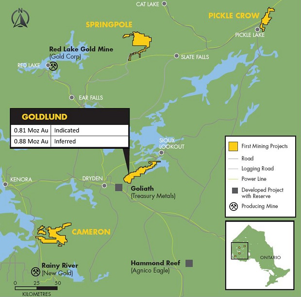
Location: 60 km NE of town of Dryden, Ontario, Canada
Area: 28,572 hectares
Metals: Gold
On June 17, 2016, First Mining completed an amalgamation with Tamaka Gold Corporation, a privately held mineral exploration company that owned the Goldlund Gold Project (the "Goldlund Project"). The Goldlund Project is situated within a land package of approximately 280km2 referred to as the Goldlund Property (the "Property"). The Property has a strike-length of over 50km in the Wabigoon Subprovince, and consists of 1,348 mining claims totalling 28,015 hectares ("ha"), 27 patented claims (totalling 443 ha), one mining lease (48.56 ha) and one licence of occupation (74.84 ha). The property has been extensively explored and hosted an underground and open-pit mine between 1982 and 1985.
The Goldlund Project is an Archean lode-gold project located in northwestern Ontario, approximately 60 km northeast from Dryden by road (Ontario Provincial Highway 72) and stretches over several townships of the Patricia Mining and Kenora Mining Divisions of northwestern Ontario.
WSP Canada Inc. ("WSP") was commissioned by First Mining in 2018 to issue an updated mineral resource estimate and complete a technical report for the mineral deposit at the Goldlund Project. The technical report, which is titled "Technical Report and Resource Estimation Update, Goldlund Gold Project, Sioux Lookout, Ontario" with an effective date of March 15, 2019 (the "Goldlund Technical Report"), can be found under First Mining's SEDAR profile at www.sedar.com, and on First Mining's website. The report has been prepared by WSP in accordance with National Instrument 43-101 Standards of Disclosure for Mineral Projects ("NI 43-101"), Companion Policy 43-101CP to NI 43-101, and Form 43- 101F of NI 43-101.

Project Highlights:
- Advanced stage exploration project
- Indicated Resource: 12.86 Mt grading 1.96 g/t Au containing 809,200 ounces of gold
- Inferred Resource: 18.36 Mt grading 1.49 g/t Au containing 876,954 ounces of gold
- Excellent infrastructure including access to roads and power
- Large land package with considerable exploration upside potential
Goldlund Mineral Resource Estimate (by zones) within a US$1,350/oz Whittle pit shell:

Notes:
- Based on the technical report titled "Technical Report and Resource Estimation Update, Goldlund Gold Project, Sioux Lookout, Ontario" with an effective date of March 15, 2019, which was prepared for First Mining by WSP Canada Inc. in accordance with NI 43-101, and which is available under First Mining's SEDAR profile at www.sedar.com.
- The overall stripping ratio for the whittle pit is 4.71:1.
- A base case cut-off grade of 0.4 g/t Au was used for this updated mineral resource estimate.
- Resources are stated as contained within a conceptual pit shell using a metal price of US$1,350 per ounce of gold, mining costs of US$2.00 per tonne, processing plus G&A costs of US$15.40 per tonne, 93% recoveries and an average pit slope of 48 degrees.
- Mineral resources are not mineral reserves and do not have demonstrated economic viability. There is no certainty that all or any part of the mineral resources will be converted into mineral reserves.
- Mineral resource tonnage and contained metal have been rounded to reflect the accuracy of the estimate, and numbers may not add due to rounding.

Goldlund Geology and Mineralization
The following has been extracted from the Goldlund Technical Report. For further details, see the full text of the Goldlund Technical Report, available under First Mining's SEDAR profile at www.sedar.com.
The Property is situated within a northeasterly-projecting arm of the Wabigoon Subprovince that extends from Wabigoon Lake to Sioux Lookout. The area is underlain by sedimentary and volcanic rocks, numerous intermediate to mafic subvolcanic intrusive sheets, and is intruded by several granitoid stocks. The stratigraphic assemblage is subdivided into five principal rock groups: the Northern Volcanic Belt, Northern Sedimentary Group (Abram Group), Central Volcanic Belt (Neepawa Group), Southern Sedimentary Group (Minnitaki Group), and the Southern Volcanic Belt. The area has been affected by multiple deformational events, resulting in a dominant northeast trending structural fabric. The majority of identified mineralization is hosted within the Central and Southern Volcanic Belts.
Gold mineralization appears to be concentrated in quartz-filled fractures that trend 005° to 015° and dip 35° to 50° towards the northwest. These fractures are concentrated in zones that display an intermittent, 200 to 300 m spacing for a total strike-length of 3 km. The identified fractures have been investigated to a vertical depth of 200 to 400 m.
Source: https://firstmininggold.com/projects/ontario/goldlund-project/

|