Manitou Gold Inc.
Goudreau Property
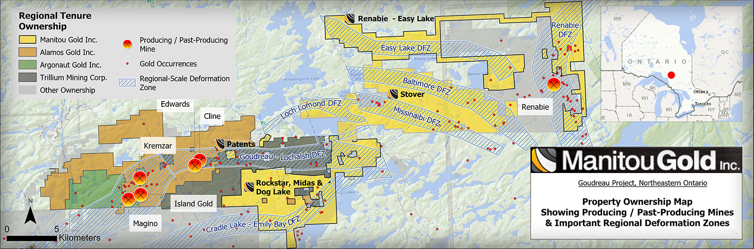
The Goudreau properties consist of 22,500 hectares of consolidated prospective gold properties on the Michipicoten Archean Greenstone Belt. The lands assembled consist of 37 kilometres of strike length with at least seven under-explored large-scale deformation zones showing favorable lithology. The deformation zones known as the Goudreau-Lochalsh DFZ and the Emily Bay DFZ are hosted on the properties identified as; RockStar, Midas and Dog Lake. The more recently acquired Easy Lake – Renabie East and Stover Properties host the Loch Lomond, Easy Lake, Baltimore Missinaibi and Renabie deformation zones. The entire set of properties are set between Alamos Gold, Island Gold Mine and the past producing Renabie Mine (Barrick) near the town of Missanabie.
The Goudreau-Lochalsh area currently hosts exploration on the western side of the belt as Argonaut Gold in the final stages of their Advanced Exploration of the Magino Mine property which is a past producing underground gold mine set inside their land package area totaling 2,204 hectares. This project has recently received a positive feasibility study which was published December 2017 and showcases their open-pit mining opportunity.
Prospectivity of the jurisdiction is very high, several companies have committed multi-million dollar exploration budgets to explore the area, making the Michipicoten Greenstone Belt one of the most interesting high grade gold jurisdictions in Ontario.
REGIONAL GEOLOGY
The Goudreau-Lochalsh area was regionally mapped by E.L. Bruce (1942) and in more detail by the OGS in 1992 by Heather and Arias (1992) and Sage (1994). The following regional description is summarized from the report, “Geological and Structural Setting of Gold Mineralization in the Goudreau-Lochalsh Area, Wawa Gold Camp” by K.B Heather and Z. Arias (1992) and “Geology of the Michipicoten Greenstone Belt” by R.P. Sage (1994).
The Goudreau Property is located within the Wawa subprovince of the Superior Province in the Canadian Shield. The property is located within an Archean greenstone belt known as the Michipicoten Greenstone Belt which is interpreted to be a monoclinal sequence of supracrustal rocks that have been thickened by regional folding (Figure 5). This greenstone belt contains a wide variety of supracrustal rocks that are typical of Archean greenstone belts (Sage, 1994). Regional inverted folds have been identified within this belt and it has been concluded that the present exposure level of the belt is the overturned limb of an early, belt-scale recumbent nappe fold (F1), that was refolded and imbricated by south-verging thrusts (F2) (Figure 6) (Heather and Arias, 1992). The southern portion of the Michipicoten greenstone belt has the geometry of a thrust-faulted, inverted syncline (F2), while the northern portion of the belt has the geometry of an inverted anticline (F2), known as the Goudreau Anticline (Heather and Arias, 1992), or Centre Anticline (Goodwin, 1962)
Rocks in the immediate Goudreau-Lochalsh area consist of felsic to intermediate, pyroclastic metavolcanics capped by pyrite-bearing iron formation (Heather & Arias, 1992). Gabbro and quartz diorite dykes and sills intrude all volcanic rocks that comprise the Michipicoten Greenstone Belt (Jamieson, 2004). Felsic intrusions ranging in composition from nepheline syenite to tonalite/trondhjemite occur within the area (Heather & Arias, 1992). The metamorphic grade in the Goudreau-Lochalsh area is predominantly greenschist facies with the exception of a narrow band of amphibolite grade metamorphism adjacent to the granitoid rocks to the north (Heather & Aries, 1992). Northwest and northeast striking diabase dikes cross-cut all aforementioned lithologies (Heather & Aries, 1992)
Two subparallel, regionally extensive zones of deformation, the Goudreau Lake Deformation Zone (GLDZ) and the Cradle Lakes Deformation Zone (CLDZ), have been defined within the area ((Heather & Aries, 1992). The GLDZ, which is a 4.5 km wide, >30 km long east-northeast to east striking arcuate zone subparallel to major lithological and foliation trends, hosts the majority of known gold deposits and occurrences throughout the area. The GLDZ is coincident with a major lithological contact between felsic to intermediate pyroclastic metavolcanic rocks (Cycle 2) to the south and massive to pillowed mafic metavolcanics rocks (Cycle 3) to the north (Heather and Arias, 1992).
The Cradle Lake Deformation Zone (CLDZ) is approximately 5-10 km in length, 1-2 km in width and is located to the south of the GLDZ (Heather & Aries, 1992). To the south of the GLDZ is the subparallel trending Goudreau Anticline which is interpreted as a doubly plunging anticline with a central axis trending 070 degrees (Jamieson, 2004). The axial trace of the Goudreau Anticline is located approximately 2.5 km south of Manitou Gold’s Goudreau Property Patents (Figure 7).
The GLDZ can be subdivided into four structural domains based on the style of deformation, lineation patterns and the orientation and sense of apparent shear displacement on sets of high-strain zones (Heather & Aries, 1992). The four structural domains (northern, southern, western and eastern) dictate the style and geometry of the associated gold mineralized zones (Figure 8).
The Southern Domain is approximately 8 km long, 2 km wide and occupies the south central portion of the GLDZ. It consists of a ductile-brittle zone of subparallel, dextral oblique-slip high-strain zones that strike 070° and are developed within strongly altered and deformed felsic to intermediate metavolcanic rocks (Heather and Arias, 1992). To the east, the possible extension of this domain is covered by thick glacial overburden with little bedrock exposure. As such, the continuity of the southern domain to the east is unknown. The dominant structural feature of the southern domain is the “Goudreau Shear” which hosts the Magino Mine, the Lochalsh Zone and the Island Zone (Heather and Arias, 1992). Horizontal to sub horizontal striations and crenulation lineations with locally steeply plunging mineral lineations exist throughout this domain (Heather and Arias, 1992).
The Northern Domain is located immediately south of the Maskinonge Lake stock and is approximately 4 km long and 1 km wide (Heather and Arias, 1992). It is composed of brittle to brittle-ductile high-strain zones oriented at high angles to the regional foliation / schistosity. The narrow, high-strain zones are up to tens of metres wide and may or may not contain concordant quartz veins and narrow (mm to cm scale) brittle shears or fractures (Heather and Arias, 1992). These high-strain zones occur in two main sets, one which strikes northeast-southwest (030°) and displays sinistral, oblique slip displacement and the second strikes northwest-southeast (140°) and displays dextral, oblique-slip displacement (Heather and Arias, 1992). Within this domain, mineral lineations within the high strain zones plunge to the north-northwest and lineations formed by the intersection of shear fabrics plunge slightly steeper to the northwest (Heather and Arias, 1992). The northern domain hosts the Kremzar Mine which is located within a 120° to 140°-striking high-strain zone, as well as the No.2, the No.3, the No.8 and the Rusty Zone occurrences.
The Eastern Domain of the GLDZ is approximately 9 km long and 2 km wide and contains narrow brittle and brittle-ductile high-strain zones displaying dextral, oblique-slip displacement. High strain zones within this domain are dominantly parallel or at low angles to the east-striking regional foliation fabric. The eastern domain hosts the Cline Lake Gold Mine, the Edwards Gold Mine and the Markes gold occurrence. The patents that comprise Manitou Gold Inc.’s current Goudreau Property are located within the Eastern domain of the GLDZ.
Work on the Western Domain is less extensive than the other three domains of the Goudreau Lake Deformation Zone; however similarities to the characteristics of the eastern domain exist throughout this area. This domain is composed of brittle and brittle-ductile high-strain zones which strike primarily 085°-115° and display dextral oblique-slip displacement with lineations plunging moderately to steeply to the west (Heather and Arias, 1992). The Murphy Gold Mine is located within the western domain.
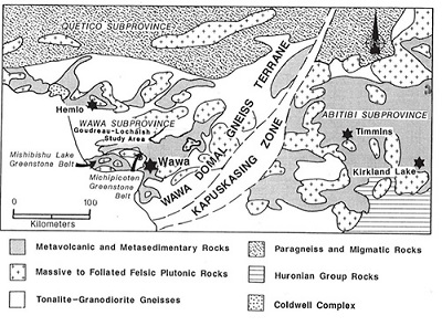
Figure 5: Regional geological setting of the Michipicoten greenstone belt and the Wawa gold camp (modified from Heather and Arias, 1992)
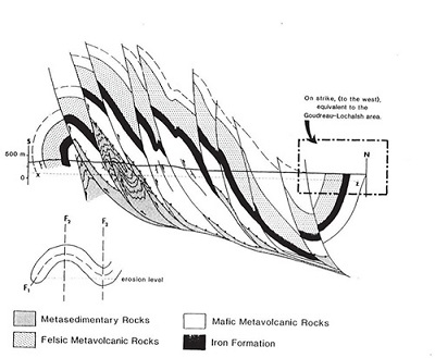
Figure 6: Composite structural section through the central part of the Michipicoten greenstone belt (Heather and Arias, 1992)
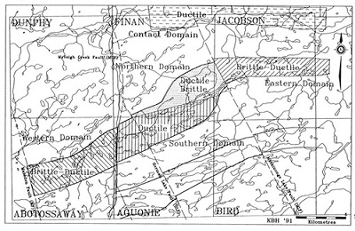
Figure 8: Deformation Zones of the Goudreau-Lochalsh area showing structural domains and their associated structural style (Heather and Arias, 1992)
PROPERTY GEOLOGY
The Property lies within the Eastern domain of the Goudreau Lake Deformation Zone (Figures 7 & 8). This domain is 9 km long and 2 km wide and contains narrow east (085° and 115°) striking brittle and brittle- ductile high-strain zones displaying dextral, oblique-slip displacement (Heather and Arias, 1992). In the Cline Lake area, mineral lineations have a consistent shallow plunge to the east and become moderately to steeply (45-70) east plunging in the Godin Lake area (Heather and Arias, 1992). High strain zones, laminated quartz-tourmaline and /or quartz-Fe-carbonate veins, fractures and felsic porphyry dykes are predominantly parallel to (or at low angles to) east-striking regional foliation (Heather and Arias, 1992).
Distinct lozenge or diamond shaped fracture patterns characterize the brittle high-strain zones and are best observed in quartz-feldspar porphyry dykes and sills (Heather and Arias, 1992). Brittle-ductile deformation can be seen as millimetre-scale high-strain zones along which offset of centimetre-scale quartz veins can be observed (Heather and Arias, 1992). Sigmoidal fabrics representing ductile high-strain zones occur at contacts between felsic porphyry dykes and mafic metavolcanics (Heather and Arias, 1992). Unlike the strong deformation that can be seen in the rocks of the southern domain of the GLDZ, the eastern domain is characterized by narrow zones of intense strain directly adjacent to rocks of weak to moderate deformation intensity (Heather and Arias, 1992). The eastern domain of the Goudreau Lake Deformation Zone is truncated on the west by the northwest trending Maskinongo Lake Fault, and hosts several gold occurrences including, but not limited to, the Cline Lake gold mine, the Edwards gold mine and the Markes gold occurrence. Manitou Gold Inc.’s current patented property holdings lie approximately 900 m to the east of the Markes gold occurrence and directly adjacent to the McColl gold occurrence within the Eastern domain of the GLDZ. The McColl gold occurrence is hosted by sheared and altered mafic metavolcanics and intrusive rocks. Gold values are associated with quartz-Fe-carbonate-pyrite-pyrrhotite lenses within a high strain zone (MDI42C08SW00019). Altered and deformed porphyry dykes also occur within the vicinity of the occurrence.
Initial inspection of the Goudreau Patents by Manitou Gold in November, 2017 has confirmed the presence of an increasing level of structural deformation across the property. Lithological units observed during a brief visit consist of sheared and altered mafic metavolcanics with up to 20% quartz-carbonate veinlets parallel to dominant foliation. Shearing across the northern portion of the property occurs at an orientation of Az 280°/80°N. A secondary quartz vein set oriented Az 170°/57°W was also observed in outcrop. The presence of the GLDZ across the property in conjunction with favorable lithological units for gold mineralization paired with the lack of exploration records across this property make it a prime target for gold mineralization potential.
The Goudreau-Lochalsh area has been the scene of mining exploration for almost a hundred years. In this time numerous gold prospects have been discovered. Gold mineralization across the Goudreau-Lochalsh area occurs in quartz veins located within high-strain zones in all rock types, excluding diabase sills (Heather and Arias, 1992). A spatial association occurs between gold mineralization and felsic porphyry dykes and stocks, with the contacts of these dykes being particularly favorable sites for shearing and subsequent gold deposition (Heather and Arias, 1992).
Alteration associated with gold mineralization is confined to the discrete high-strain zones and consists primarily of biotite, Fe-carbonate, pyrite, pyrrhotite, quartz and minor potassium feldspar within the mafic metavolcanic and metaintrusive rocks (Heather and Arias, 1992). Felsic metavolcanics and metaintrusive rocks are typically altered to an assemblage of quartz, sericite, pyrite and Fe-carbonate, albite, hematite, pyrite and or pyrrhotite (Heather and Arias, 1992). Alteration within the Cline mine area (approximately 2 km west of Manitou Gold Inc.’s patented claims consists primarily of ankerite, sericite with pyrite and/or pyrrhotite and locally magnetite as veins and disseminations (McBride ,2009).
Gold occurrences in the area are variously in quartz veins, shears, and sulphide zones, primarily located in mafic metavolcanic rocks north of the central felsic volcanic sequence (McBride, 2009). Regionally, gold exploration should follow the felsic-mafic contact zones, as this rheological contrast may represent areas of preferential gold mineralization. Gold occurrences are associated with small felsic bodies that occur within a kilometre of the main felsic volcanic complex (McBride, 2009). Structural controls appear to be the most important factor in the localization of gold-bearing quartz veins within the GLDZ, which is comprised of numerous, systematically oriented shear zones (Edgar, 2013)
HISTORY OF EXPLORATION ON THE GOUDREAU PROPERTY
The patents covering the current Manitou Gold Inc. Goudreau Property date back to the 1930’s and there is no record of mineral exploration across the patents. Work performed on the staked mineral claims that comprise the current Goudreau Property (Claims 4285174 & 4285175) is also sparse, but seems to include line cutting and overburden stripping recorded by Longbow Exploration Inc. in 1997. A report that includes the results obtained from these programs did not accompany the filed expenditures for such.
More regionally, the area around the towns of Goudreau and Lochalsh has been prospected since the turn of the twentieth century with the discovery of iron ore in the Michipicoten area southwest of Wawa. The Earliest gold exploration in the Goudreau-Lochalsh area dates back to 1896 with the discovery of gold at Emily Bay located approximately 9 km to the southeast of Manitou Gold’s current Goudreau Property.
Intense gold exploration in the 1920s and the 1940s led to the discovery of significant deposits such as the Kremzar, Magino, Cline and Edwards Properties (Perkins, 2002) Due to increasing gold prices and flow through funding in the 1980s, exploration within the area increased. Companies such as Amax, Muscocho Explorations Limited, Canamax Resources Inc., Esso Minerals, Spirit Lake Exploration Limited, Golden Myra Resources and Corona Corporation completed significant exploration activities in the area which ultimately led to the development of advanced exploration and mining at the Kremzar (production of 46,798 oz Au @ 0.139 oz/t) and Magino Mines (~110,000 oz Au @ ~0.135 oz/t) and the Cline Mine (63,328 oz Au @ 0.19 oz/t) (Perkins, 2002). Production at the last of these mines ceased in 1992, while the Edwards Mine operated by River Gold Mines suspended operations in 2001 (Perkins, 2002).
More recently, the Island Gold mine operated by Richmont Mines Inc. (acquired by Almos Gold Inc in November, 2017) began operations in October, 2007 and has produced over 500,000 oz of gold to date (Almos Gold Inc., November 24, 2017). Manitou Gold Inc.’s Goudreau Property is located approximately 9.5 km northeast of Island Gold mine along the same Goudreau Lake Deformation Zone.
Source: https://manitougold.com/projects/goudreau-property/overview/
