Orefinders Resources Inc
Knight Project
Orefinders’ Knight Project is located along Highway 560 in the Knight and Tyrell townships of Ontario, approximately 80km east of Gogama, and ~100km southwest of Kirkland Lake. The entire Knight Project land package encompasses ~2,200 ha and consists of 14 patented leases and 79 mining claims, and is a consolidation of six proximate, high-potential properties with similar geology and significant drilling, exploration or development, including: Tyranite, Tyranite Extension, Minto, Duggan, Porphyry Lake, Fawcett, and Corona.
Geology
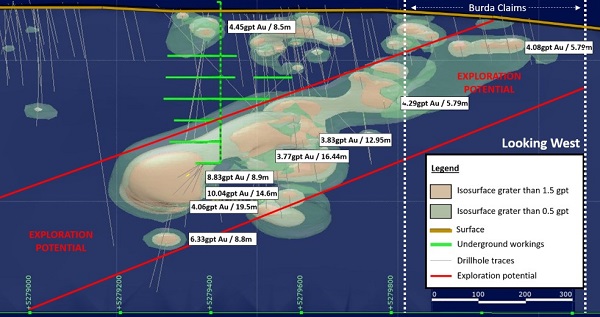
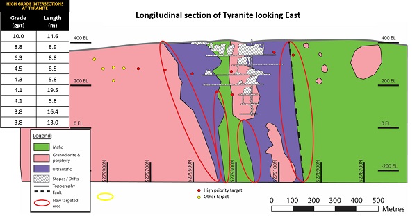
Tyranite extends over 1km along a northerly trending shear and consists of 3 lenses down to a depth of 350 metres. Tyranite is a past producing mine and the property includes a head frame and shaft down to 343 metres, as well as 1,370 metres (4,500 ft) of drifts developed between 1939-1942. During this time, ~232,000 ounces of gold was mined at an average grade of 0.147 ounces/t (5 g/t Au). Significant infrastructure exist on site—recent developments include a field office, sleeping accommodations, core cutting and logging facilities. The project hosts a historical resource of 472,000 tons grading 6.9 g/t Au. Refer to the note on historical resources on this page.
3D Interpretation of Tyranite Orebody
Exploration Plan
Historical exploration on Tyranite shows that grades are high enough to be economic. The key to the project is to delineate sufficient economic grade mineralization within the mine infrastructure to justify rehabilitation of the shaft and renewed underground exploration.
New Interpretations at Tyranite
3D inversion of a high-resolution magnetic survey allowed us to redefine the geological model at Tyranite by focusing more on the contact zones of the ultramafics. Historically, Tyranite was simply mined as a ‘fault’ style deposit. Orefinders’ interpretation focuses on the contact zones of the ultramafic units striking at right angles to the fault. Tyranite has never been drilled using this specific model/interpretation.
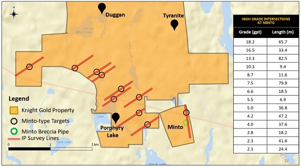
Minto
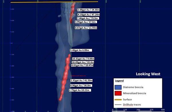
Minto is a high-grade breccia pipe, drilled from surface to over 800 metres depth. The historical resource at Minto consists of a pod of carbonate sulphide breccias, with ~204,000 tonnes grading 0.2 oz/t (6.9 g/t) to a depth of 229 metres (750 ft). Refer to the note on historical resources on this page.
Notable Drill intersections at Minto include:
- 18.2 gpt Gold (7.9 gpt if cut to 31.1 gpt) over 65.7 metres and 4.61 gpt Gold (3.5 gpt if cut to 31.1 gpt) over 79.6 in drill hole MC-09-02
- 13.3 gpt Gold (11.0 gpt if cut to 31.1 gpt) over 82.5 metres in drill hole MC-09-01
- 1.15 gpt Gold over 280 metres, including 5.2 gpt Gold over 3.44 metres, 3.2 gpt Gold over 5.47 and 3.4 gpt Gold over 41 metres in drill hole MC-10-03b
- 1.01 gpt Gold over 192.0 metres, including 5.04 gpt Gold over 24.4 metres in drill hole MC-11-11
3D Interpretation of Minto Orebody
Exploration Plan
In spite of seeing very high grades, including abundant visible gold, Minto’s breccia requires additional work to increase tonnage and recoveries to boost its gold ounce per vertical metre. The proposed work program is aimed at confirming the width of the mineralized breccia at depth (below 229 metres), beneath the diabase dyke.
Orefinders reprocessed high-resolution magnetic data at Minto, using the Minto pipe as a reference. The new survey shows three dozen similar magnetic anomalies within the same formation that hosts Minto and Porphyry Lake systems. Furthermore, Orefinders conducted ground sampling on all three dozen targets and have confirmed 10 targets for follow up IP surveying, given the Minto Breccia Pipe responds to the IP survey. Any anomalous targets from the IP survey will be drill tested. The discovery of new breccia pipes could significantly improve the economics and increase the scale of Minto.
Duggan
Duggan is located 1.5 km west of Tyranite, and hosts similar geology and potential for a high-grade open pit. Previous owners of the property confirmed historical work and expanded the strike extension of the mineral zone to 700 metres, and to a depth of 410 metres.
Previous drilling on the property yielded near surface intersections—notably:
2.14 g/t Au over 49.9 metres (1316-08)
2.73 g/t Au over 32 metres (1316-09)
7.23 g/t Au over 6 metres (CD13-03)
3D Interpretation of Duggan Orebody

Exploration Plan
The known mineralization at Duggan is rich and wide enough to consider an open pit which could be a significant contribution to the overall project. The proposed work program calls for validation of historical drilling and a drill program to increase mineralization for a maiden resource and possibly a PEA.
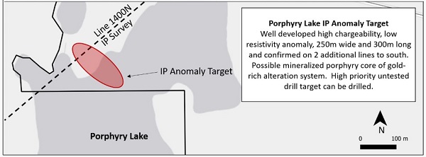
Porphyry Lake
Porphyry Lake hosts two gold mineralized porphyry systems with wide, low-grade gold intersections in drilling. Mineralization is consistent with a mineralized porphyry system that has the potential of developing into a large, bulk tonnage open pitable deposit. The property also potentially hosts breccia pipes similar to that at Minto, as it is located immediately to the west of Minto, and contiguous to Tahoe’s Juby north boundary.
Notable intersections include:
1.88 g/t Au over 20.7 metres (PL-3)
1.34 g/t Au over 21.3 metres (PL-04-02)
3D Interpretation of Porphyry Lake Orebody

Exploration Plan
The exploration plan at Porphyry Lake revolves around 2 main objectives: 1) find a center of porphyry-type gold mineralization with open pit potential; and 2) find additional Minto-type breccia zones, which are small but very high grade.
Orefinders has identified a major, untested IP high chargeability/low resistivity anomaly over 300m long by 250m wide under Porphyry Lake. We believe that there is a large gold system centered on Porphyry Lake, which shows multiple significant intersections surrounding the large, untested IP target–which has never been previously drilled. Orefinders will focus on drilling this target.

Source: http://www.orefinders.ca/consolidation-overview/

|
Geologist
If you are a geologist and interested in working with a dynamic team in the Kirkland Lake area, please send your resume and cover letter to careers@oregroup.ca