Rogue Resources Inc.
Langmuir Project
Langmuir Property is accessible by road and is only 25 km south of South Porcupine, Ontario. The property is also located seven km by road from Liberty Mines Nickel mill which has a capacity of 2000 tonnes/day. Langmuir is comprised of 74 contiguous unpatented mining claims of 856 units (13,841 hectares).
At Langmuir the primary exploration target is Kambalda style nickel sulphide mineralization occurring in ultramafic flows and sills. The Langmuir Property includes over 30 km of terrain comprised of ultramafic and mafic flows and sills favourable for hosting nickel, copper and platinum group mineralization (PGM).
Air borne geophysics has been flown over the entire property by Geotech using VTEM B-field system. More than 20 separate clusters of airborne EM anomalies have been identified.
The Langmuir nickel deposit was found by drilling one of the anomalies in one of the clusters in early 2007. Several other VTEM anomalies and clusters appear on strike with the discovery zone. These anomalies occur in an arcing trend that wraps around the Shaw Dome. This geological environment bears a striking similarity to Kambalda nickel ore deposits which are localized along the flanks of the Kambalda Dome in Western Australia.
Nickel ore deposits in the Kambalda camp often occur in groups or clusters. For example, 12 nickel deposits occur within an ultramafic flow unit of approximately 8 km by 4 km in area. At Langmuir the ultramafic flow package is 20 km long and up to 4 km wide. Therefore, the potential exists on the Langmuir Property to have one or more clusters or groupings of Kambalda style nickel deposits.
Geology and Mineralization
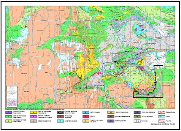
The Langmuir W4 is hosted by ultramafic rocks that form part of, or intrude, the Tisdale assemblage that flank the Shaw Dome and form part of the Abitibi greenstone belt (“AGB”). To date five Ni-Cu-(PGE) deposits have been documented in the Shaw Dome (Redstone, Hart, McWatters, Langmuir #1, Langmuir #2), and numerous showings have been identified. These five deposits occur in komatiitic rocks found within the Deloro assemblage near the base of the Tisdale assemblage. The Langmuir W4 deposit is similar to these, representing a new discovery in the Shaw Dome.

The Langmuir Property is predominantly underlain by the middle and lower formations of the Tisdale Group which consist of linear sequences of mafic volcanic units or ultramafic units. The mafic sequences consist of massive to pillowed basalt/andesite flows whereas the ultramafic sequences consist of mesocumulate to adcumulate peridotite flows with distinct spinifex textured flow tops. The flow tops indicate younging to the south. Graphitic argillite units are locally present between the peridotite flows. The mafic-ultramafic sequences are locally intruded by north trending Matachewan diabase dykes and north-east trending Abitibi diabase dykes.

The Langmuir W4 deposit is interpreted to consist of three sub-parallel nickel mineralized zones hosted by east – west trending komatiitic peridotite flows. The east-west strike extent of the zones has been defined for at least 200 metres to date. The three interpreted sub-parallel nickel mineralized zones occur within specific komatiitic peridotite flow units. They are vertical to steeply north dipping at 70 to 75 degrees.
Research indicates that the komatiite hosted nickel deposits in the Timmins area are similar to the Achaean age nickel deposits of the Kambalda and Windarra areas in Western Australia.
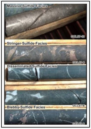
Experimental studies indicate that komatiitic magmas/lavas were emplaced at very high temperatures. The genesis of the Shaw Dome and the Australian deposits is attributed to the combined effect of lava channels (or channelized sheet flows) and intrusives, which provide the heat and metal sources and sulphide bearing iron formations in the footwall that, provide an external sulphur source. Thermal erosion of the underlying rocks by the komatiite flows is considered to be the dominant mechanism for adding sulphur to the magma and to the creating of a depositional ‘trough’ for sulphide minerals. Langmuir W4 nickel zones usually comprise of a lower horizon of stringer/fracture filling sulphides to massive or semi-massive-massive sulphides, which are stratigraphically overlain by disseminated to blebby sulphide zones. Massive sulphides within the lower horizon can grade up to 17.9 percent nickel. Nickel grades are typically a half to three percent within the upper disseminated sulphide horizon. Locally massive sulphide veinlets also occur mainly in the basal lower horizon. Sulphide modal abundance within the lower horizon is usually over 15 percent, whereas within the upper horizon the sulphide modal abundance varies from three to 15 percent.
Exploration Drill Hole Results
The Exploration commenced on the Langmuir Property in 2005. A total of 130 holes have been drilled on the Langmuir Property between May 2005 and April 2010. All holes were drilled from the surface and were land based. Within Langmuir W4 drilling was conducted on a tight pattern of approximately 25 metres spacing with one, two, or three drill holes per setup. The 2007 drill program holes were all drilled at an azimuth of 320 to 325 degrees and with dip angles of 45 to 60 degrees; whereas 2008 drill holes were drilled southward at azimuths varying from 195 to 176 degrees with dip angles of 45 to 70 degrees. After the Langmuir W4 discovery hole GCL07-06, a small field grid was cut. The field grid consisted of a 1.2 kilometre base line and twelve 450 metre long cross lines spaced 50 metres apart. The drilling grid base line is oriented at 055 degrees. Every 2007 drill hole in the Langmuir W4 area was spotted using a field measuring tape and a compass. All 2008 drill holes were spotted with a Differential GPS (“DGPS”). After the 2007 drill holes were completed, the top of the collar casing location ((NAD83 datum, Zone 17N), was surveyed using a DGPS. During drilling operations, the down hole orientations of all drill holes were surveyed using a Reflex EZ-Shot instrument, with readings were taken 15 metres below the casing, then nominal at 50 metre intervals for the remaining length of the hole and finally at the end of the hole.
Resource Estimate
Rogue Resource geologists and SRK Consulting (Canada) Inc. have modeled the shape and size of the Langmuir W4 nickel deposit and compiled a resource estimate in 2010.

* Mineral resources are reported in relation to optimized pit shells. Mineral resources are not mineral reserves and do not have demonstrated economic viability. All figures are rounded to reflect the relative accuracy of the estimate. All assays have been capped where appropriate.
**Open pit mineral resources are reported at a cut-off of 0.40 percent nickel inside a conceptual pit shell. Underground mineral resources are reported at 0.70 percent nickel and include resource blocks above cut-off outside the conceptual pit shell. Cut-off grades are based on a nickel price of US$8 per pound and a metallurgical recovery of eighty-seven percent, without considering revenues from other metals.
Source: https://www.rogueresources.ca/langmuir-project

|