Galleon Gold Corp.
Neal Gold Project
Geology
Neal is a high grade gold-dominant discrete vein system with at least 5 veins known to date. Test mining in recent years from the top of the historic vein zones exploited near surface stockwork veining left behind by previous operators. Most of the veins are parallel and strike north-easterly with moderate southerly dips within a regionally extensive fault system, probably related to the nearby Trans-Challis fault zone. Veining consists of quartz- white mica- clay, with the better gold grades directly related to iron oxides after pyrite near surface and pyrite at depth. The primary host rock is a fairly uniform Cretaceous-age biotite granodiorite that is part of the southern margin of the extensive Atlanta Lobe of the Idaho Batholith. Tertiary-age bi-modal lamprophyre and rhyolite dikes intrude the same faults that host the vein zones at Neal; a common theme in many other gold mines in the region.

Property Description
The Neal Gold Project is located near Boise, Idaho and has excellent access via 20 kilometers of improved gravel and dirt roads from Interstate-84. A 25-minute commute from Boise provides easy access to the many private and government services available in Idaho’s largest city. The rolling hills in the area are part of the Danskin Mountain Range, but are arid and mostly covered by sage and scrub-brush. Although one small underground gold mining operation is located approximately 4 miles on strike to the southwest from Neal, most of the industry in the immediate area is ranching related. Neal private property consists of 5 patented mining claims covering approximately 22.4 hectares (55.38 acres) and another 7 unpatented lode claims covering about 52.6 hectares (130 acres) located on Forest Service administered public lands.
Property Ownership

Historic Underground Gold Mining
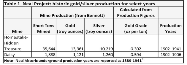
The project site was the most productive gold producer in the Neal Mining District, with underground production from 1889 through 1941 sourced mainly from the Hidden Treasure, Homestake and Daisy Mines. According to US Bureau of Mines records, the Neal Mining District is estimated to have reported production of at least 30,000 ounces of gold, with most of this coming from the Neal property1. Table 1 provides a summary for a select range of historic underground production years for which data is available.
Historic Exploration Drilling and Trenching
In the 1989-1990 time period, Centennial Mining completed a reverse circulation drill program targeting near surface oxide gold mineralization that consisted of 190 vertical and 18 angle holes totaling 47,655 ft (14,525 m). Although this drilling was not the first at Neal, it was the first extensive program intended to define a resource for a contemplated open pit heap leach gold operation. The program was generally successful in identifying five vein zones and accessing near surface oxide potential.
Later work in the 2007-2013 timeframe by Aquasolum Consultants followed up key intercepts (Table-2) from the earlier Centennial program with additional trenching. This detailed surface trench work better defined vein and stockwork gold mineralization found in the earlier drilling and produced samples for metallurgical and mine development studies.

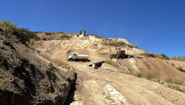
Recent Bulk Sampling
In 2015, Neal Development LP started development work on an open cut exploration program at the Neal mine. This program was designed to provide adequate sample volume for further metallurgical and mill recovery work. The open cut produced a 12,900 ton sample of gold mineralized material that averaged 0.140 troy ounces per short ton (opt); this stockpile remains onsite. Under terms of the MOU, Sprott Mining retains the rights to the stockpiled material.
The Neal Mine Project is a fully permitted Mine Operation. An environmental reclamation plan approval, which becomes the operating permit, was issued for the Neal Gold Project on April 20, 2017 and a surety bond of $87,500 was posted allowing for exploration drill programs, underground development and shipping ore offsite. Any additional mining of the open pit will require an additional $87,500 be added by the operator.
The technical information contained on this webpage has been reviewed and approved by Thomas H. Chadwick, a Qualified Person under National Instrument 43-101 Disclosure Standards for Mineral Projects.
Plans for 2019-2020
In the near term, Pure Nickel technical personnel will organize and assess existing exploration data from past operators and complete an updated geologic map and surface sampling program. Historic data will be combined with surface geology/geochemistry and any new drill data to better define underground vein targets. This is expected to allow for selective targeting during a follow-up drilling program later in the year.
Comments on Historic Drilling and Sampling
The Company has not done sufficient work to verify historic drilling or sampling results. However, the Company considers that the historic information is relevant for early-stage project assessment based upon Pure Nickel’s due diligence work, which includes property visits and the review of historic reports, maps, and technical data.
Sources Cited
1 Bennett, Earl H., 2001. The Geology and Mineral Deposits of Part of the Western Half of the Hailey 1° x 2° Quadrangle, Idaho, USGS Bulletin 2064-W, prepared with Idaho Geological Survey, Idaho State University and the University of Idaho: with a section on the Neal Mining District by Thor H. Kiilsgaard and Earl H. Bennet (pp 24-29).
2 Atlanta Gold Inc. news releases dated Dec 9, 2015 and April 26, 2017.
Source: https://galleongold.com/projects/neal-gold-project/

|