Orefinders Resources Inc
About McGarry
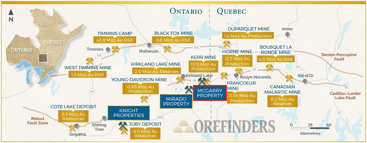
The McGarry property is in Virginiatown, Ontario within the Abitibi Greenstone Belt and spans 2.4km on one of the world’s most prolific gold structures, the Cadillac Larder-Lake Break. The property encompasses 681 hectares and is comprised of 46 Patented Mining Claims and 5 Mining Licenses.
McGarry hosts a NI43-101 indicated resource of 123,000 oz at an average grade of 7.7g/t gold (uncut or 112,000 ounces with grades top-cut to 51.4 gpt), and an additional inferred resource of 30,000 oz. at an average grade of 5.3 g/t (uncut or 29,000 ounces with grades top-cut to 51.4 gpt) as per McGarry resource estimate from 2009 (see cautionary note at the end). McGarry also has a NI 43-101 Preliminary Economic Assessment, published in 2011, which is based off McGarry’s 2009 resource estimate.
McGarry is located east of and immediately adjacent to the Kerr-Addison Mine, which was one of Canada largest gold mines producing over 12,000,000 ounces gold over a 58-year period ending in 1996 (Figure 1) (see MNDM OFR5831). Adjacent to the west of McGarry is Bonterra Resources’ Cheminis Mine and Bear Lake deposits which host a historic estimate* (2011, P+E Mining) of 3,750,000 tonnes at 5.7 g/t (683,000 oz) (inferred) and the Cheminis Deposit contains a historic estimate (2011, P+E Mining) of indicated of 335,000 tonnes at 4.1 g/t (43,800 oz) and inferred of 1,391,000 tonnes at 5.2 g/t (233,400 oz). Bonterra’s Technical Reports are available at www.sedar.ca.
On site infrastructure includes a head frame, shaft compartments, hoist, offices, and fully functional core shack all refurbished over the last ten years. McGarry is easily accessible with the Trans-Canada Highway running directly through the property.
Location and Land

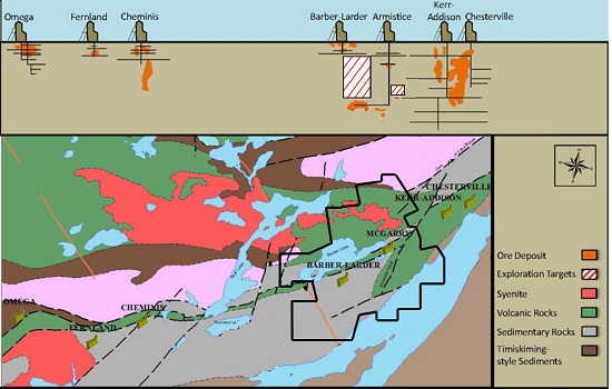
Cadillac Larder-Lake Section
McGarry Production and Infrastructure
As recently as 2013 the McGarry Mine was in production from significant underground workings and was undergoing underground exploration. Kerr/Armistice spent considerable capital upgrading the McGarry’s infrastructure including the shaft, hoist and onsite facilities necessary to extract ore from underground. Additionally, extensive underground exploration yielded outstanding grades over very long lengths, including:
325 N Zone – 2280 sublevel
- 8.2 g/t gold over 98m length and 1.5m width, Stope #1 (E & W)
- 4.6 g/t gold over 26m length and 1.3m width, Stope #1.5 (E & W)
- 7.6 g/t gold over 79.2m length and 1.4m width, Stope #2 (E & W)
325 N Zone – 2330 sublevel
- 11.1 g/t gold over 24m length and 1.7m width, Stope #1 (E)
- 6.1 g/t gold over 7.6m length and 1.2m width, Stope #2 (E)
- 4.3 g/t gold over 7.6m length and 1.8m width, Stope #2 (W)
440 N Zone – 2250 level
- 6.2 g/t gold over 18m length and 1.6m width
The above exploration results and grades include 35% dilution and are reported from Kerr Mines news release April 22, 2013 which is available on Sedar.com.
McGarry Historical Mineral Resources
The McGarry Property was the subject of a PEA study in 2011 that outlined a historical mineral resource of 447,000 tonnes grading 7.89 gpt gold for a total of 112,000 gold ounces in the Indicated Category and an additional 157,000 tonnes grading 5.83 gpt gold for a total of 29,000 ounces in the Inferred Category (Table 1 below). This estimate was based on a 3.43 gpt Au lower cut-off with assay grades limited to 51.4 gpt gold. A specific gravity of 2.79 grams per cubic metres was used along with a minimum horizontal mining width of 1.5 metres. The report is available at www.sedar.ca under Kerr Mines Inc. and its amended version was published on 30 September 2011.
McGarry Historical Mineral Resource Estimate, Armistice Resources 2011 Technical Report

Barber-Larder Open Pit
The McGarry Property also hosts the Barber-Larder open pit which produced 70,000 tonnes of materials, of which approximately 51,000 tonnes were processed at the Kerr Mill which returned a total of 6,700 ounces of gold for an average reconciled grade of 4.1 gpt gold (see MNDM AFRI file 32D04SE0006). This area of the property and its historical production are distinct from, although abutting, the production and resources on the McGarry shaft zone.
Geology
The McGarry property straddles the Larder Lake Cadillac Deformation Zone (LLCDZ) which defines a major crustal structure separating rocks of different assemblages. To the south of the LLCDZ rocks of the Larder Lake Group (Tisdale Assemblage) are overlain by and in fault contact with conglomerate, turbidites and shales of the Temiskaming Assemblage (<2674.3 ±3.7Ma) that have been folded into a southwest plunging syncline structure.
To the north of the LLCDZ mafic and ultramafic volcanic rocks, that have not been dated but appear to be Tisdale Assemblage, are overlain by Temiskaming Assemblage sedimentary rocks and folded into a northeast plunging anticline.
Within the LLCDZ the same units as above are present but highly deformed and stretched out into bands parallel to the deformation zone. The Armistice deposit contains the same ore facies as found at the Kerr Addison, namely carbonate ore which corresponds to deformed and altered ultramafic rocks, the “flow” ore which is a mylonitized tholeiitic volcanic, the graphite ore which corresponds to deformed, interflow graphitic sediment and the mineralized porphyry dykes.
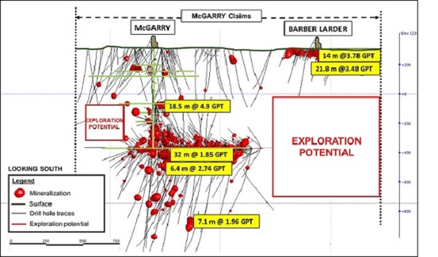
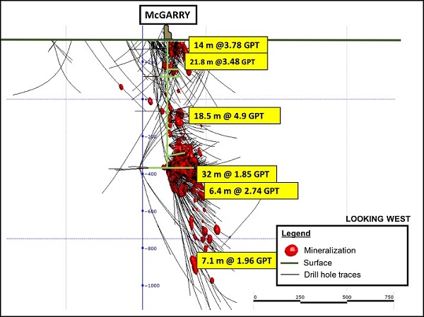
3D Interpretation of Orebody
3D Interpretation of the McGarry Shaft
3D Interpretation of Barber-Larder Open Pit

Source: http://www.orefinders.ca/overview-2/

|
Geologist
If you are a geologist and interested in working with a dynamic team in the Kirkland Lake area, please send your resume and cover letter to careers@oregroup.ca