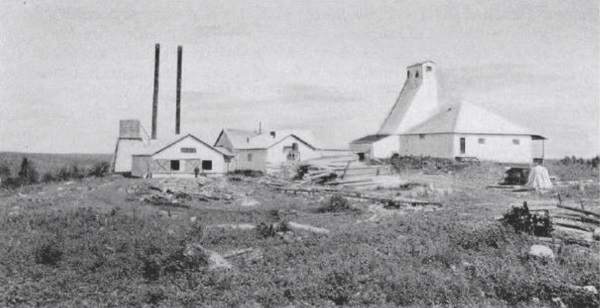
The Rowan Mine property is comprised of 119 claims. A joint venture with Evolution Mining includes 117 of these claims and the other two claims, which host the Red Summit Mine, are owned 100% by the Company. The joint venture claims are 62% owned by West Red Lake Gold and 38% owned by Evolution Mining, and include 50 patented, 18 leased, and 49 staked claims. The Rowan Mine property hosts significant regional gold bearing structures which intersect near the former producing Rowan Mine. The Rowan Mine was in development from the late 1930s to the 1950s with mine workings consisting of a vertical shaft, three levels including an adit on the first level, and underground exploration of drifting and raising along several gold zones.
The Rowan Mine Resource
Inferred Resource
|
|
Tonnes |
Grade gpt Au |
Contained oz Au |
|
TOTAL |
4,468,900 |
7.57 |
1,087,000 |
Price of gold: $1150; $US Exchange rate US$: CDN$0.77; Block cutoff grade: 3.0 gpt Au; Numbers may differ due to rounding
|
Blocks Greater than gpt Au |
Tonnage (T) |
Grade Au |
Contained oz. Au |
|
5.0 |
2,602,000 |
10.25 |
857,900 |
|
4.0 |
3,332,000 |
8.98 |
962,100 |
|
3.0 |
4,468,900 |
7.57 |
1,087,000 |
|
2.0 |
5,736,400 |
6.45 |
1,188,600 |
|
1.0 |
9,379,300 |
4.48 |
1,351,800 |
RLG has a 62% interest.
The resource information is from the NI 43-101 filed on sedar.com in Feb. 2016 and has been reviewed and approved by Ken Guy, P.Geo., a consultant to West Red Lake Gold Mines Inc. and the Qualified Person responsible for exploration at the West Red Lake Project property, as defined by NI 43-101 “Standards of Disclosure for Mineral Projects”.
The Rowan Mine property is situated on an east-west trending regional gold bearing structure known as the Pipestone Bay St Paul Deformation Zone. The regional geological structure crosses the Company property and continues east to the town of Red Lake. Gold zones are hosted within a sequence of hydrothermally altered mafic volcanics with intercalated felsic volcanics and porphyries, as well as ultramafics. Gold mineralization is associated with quartz veining and increased iron sulphide mineralization.
The prized Balmer-Confederation aged unconformity occurs both on the northern and southern portions of the Rowan Mine property as are folded iron formations and ultramafic units that have been shown to be prime hosts for the deposition for gold in the Red Lake Gold District to depths exceeding 2000m. The three former gold mines on the West Red Lake Project are situated on the Pipestone Bay St Paul Deformation Zone.
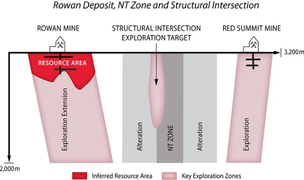
A second key geological structure is the NT Zone which strikes northeast onto the property from the neighboring Newman Todd property operated by Confederation Minerals. The regional-scale NT Zone crosses onto the West Red Lake Project from the south boundary and trends northeast for two kilometres to where it intersects with the Pipestone Bay St Paul Deformation Zone.
The intersection of two regional-scale geological structures form the Structural Intersection target area, which is located 1.5 kilometres east of the Rowan Mine Shaft. The regional folding within the structural intersection target area is highly prospective for future exploration.
Rowan Mine Property Exploration Targets
Rowan Mine Deposits
The Rowan Deposit Gold Zones have an established strike length of 1200m and remain open at depth. The Rowan Mine Gold Zones have been explored to a depth of less than 500m and contain several high grade gold zones which are a primary target of exploration for expansion to depth.
NT Zone
The goldbearing NT Zone is 2km in length and hosts several high grade gold zones.
Structural Intersection Target
The intersection of the Pipestone Bay St Paul Deformation Zone and the NT Zone occurs between 1km and 2km east of the Rowan Mine Shaft and presents a highly prospective exploration opportunity.