Advanced Projects

The advanced exploration targets are projects that are located near to the existing operations and show signs of relatively quick advancement towards the development stage, and/or are projects that have a calculated NI 43-101 Resource.
Near Mine Exploration Program - Holloway Mine
At the Holloway Mine (which boasts historical gold production of 0.9 million ounces from 1994-2004) a limited amount of exploration drilling has been carried out over the past few years and is now a key focus of the exploration program. The key targets in this area are the Smoke Deep Zone ("Smoke Deep"), which was intercepted late in 2007, while the Company was finalizing definition drilling of the Blacktop Zone for completion of a technical report, and the Deep Thunder Zone ("Deep Thunder"), which lies to the east of the Blacktop Zone, and has limited historical drilling with some significant values.
Smoke Deep Zone
Smoke Deep is located halfway between the Lightning Zone ("Lightning") to the west, and the Blacktop Zone ("Blacktop) to the east, and was originally tested towards the end of 2007, (see press release dated March 28, 2008) with a modest 6 holes drilled over approximately 500 metres of strike length.
In November of 2009, SAS commenced an intensive drilling program designed to better define the overall geometry of a zone of lower grade mineralization, and at the same time, to intersect the higher grade shoots that lie within this envelope. Using the information from the original 2007 holes, and the holes recently completed, the Company conducted a structural analysis of Smoke Deep to assist with better defining these shoots which will be the target of the next phase of drilling (see press release dated February 8, 2010).
Continued exploration is currently underway and is expected to be completed by the second quarter of this year. Once the geometry of the mineralized zone and, the distribution of gold better defined, the Company will make a decision to extend a drift from Lightning into the Smoke Deep Zone.
Advanced Targets
TAYLOR
Location, Property Description and History
The Taylor Project consists of 28 wholly-owned patented claims, leases and mineral claims in the south-central part of Taylor Township covering 1,542 hectares. The property is located 53 km east of Timmins, Ontario and is easily accessible by secondary paved roads from Highways 11 and 101. The deposits are located approximately 68 km by road west of the Holt Mill. The property is centered at 529000 E and 5379000 N in NAD83, Zone 17.
Prior to the Company's acquisition of the property, the Taylor Project area was explored by Hollinger Consolidated Mines Ltd. ("Hollinger") and by a joint venture between Labrador Mining and Exploration Company Ltd. (successor to Hollinger) and later by Esso Minerals Canada ("Esso Minerals"). The property
includes two near surface gold deposits, the Shoot Zone and the Shaft Zone and the deeper West Porphyry Zone.
The Taylor Mine Shaft Deposit was discovered in 1962 by Hollinger who did considerable drilling from 1962 to 1966 and again from 1980 until 1984. SAS earned a 50% interest in the Taylor Project by conducting a drilling program, sinking a 172 m exploration shaft and completing an underground exploration program on the property from 1986-1988. The remaining 50% interest was acquired in 1988 from Esso Minerals. In 1991 the Company processed about 6,000 tonnes of development ore grading 2.2 g/t Au from the Shaft Deposit at the Company's then owned Stock Mill. In 1998-1999 the Company reinterpreted the geology of the Shaft Deposit and drilled additional holes into the Shaft Zone.
The West Porphyry Deposit was discovered in 1962 by Hollinger. It is located some 450 m west of the Taylor Mine Shaft Deposit. Hollinger conducted drilling in that area from 1962 through 1966 and SAS conducted significant drilling on the zone from 1986 through 1988 and again in 2004 and 2005.
The Shoot Zone was discovered by Hollinger in 1972 about 2 km west of the Taylor Mine Shaft Deposit. Hollinger drilled intermittently on the property from 1972 through 1981. In 1986 through 1997 SAS drilled intermittently on the property.
Geology, Exploration and Drilling
Four gold deposits have been defined to date along the PDFZ on the Taylor property. These are the Shaft Deposit, the Main West Porphyry Deposit, the Upper West Porphyry Deposit and the Shoot Zone. The PDFZ strikes northeast in the Shoot Zone area and curves to an almost east-west trend in the Shaft Zone area. It dips at approximately 45º to the south and overlies the Porcupine Group of metasedimentary rocks. The fault zone is typically sheared, carbonatized, peridotitic komatiites altered to talc-chlorite schist. Ultramafic volcanic rocks altered to sericitized fuchsitic green carbonate with inclusions of sericitized magnesium tholeiite volcanic rocks and altered metasedimentary rocks overlie the PDFZ in Taylor township. The site geology is discussed in the Taylor section of the October, 2006, "2006 Timmins Technical Report", prepared by Scott Wilson RPA.
As indicated above, considerable drilling has been conducted on the Taylor Project. A total of 395 diamond drill holes totaling 43,803 m were drilled on the Shaft Zone from 1962 to 1998. From 1962 to 1999, 215 diamond drill holes totaling 97,571 m were drilled in the West Porphyry area. From 1972 through 1997, 99 diamond drill holes totaling 18,223 m were drilled in the Shoot deposit area. More recently in 2006, SAS drilled an additional 10 diamond drill holes targeted to test the up-dip extension of the Main Zone.
In December 2009, the Company acquired the rights to the area that lies between the Shoot Zone to the west and the West Porphyry Zone to the east. There was no previous exploration conducted in this area in the past and was the focus of the Company's 2010 Phase I drilling program which commenced in February, 2010 (see Press Release dated September 15, 2010 for summary of results). Drilling along the western portion of the Bourgeois claim intersected extensive quartz carbonate alteration similar to the Shoot Zone immediately to the west. Along the eastern margin of the Bourgeois claim, drilling intersected several wide zones of quartz carbonate alteration and quartz veining similar to that of the West Porphyry Zone. These geological results are believed to confirm the potential of the Bourgeois claim to host extensions of the Shoot and West Porphyry Zones.
A second phase of drilling commenced towards the end of 2010 with the objective to infill the resource shape to allow for higher confidence and to continue to test the areas that remain open for additional extensions of the two known zones.
Mineralization and Resources
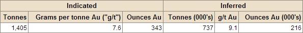
Mineral Resources at the Taylor Project are currently estimated for two areas: (i) the West Porphyry Zone,which comprises the Main West Porphyry deposit and the Upper West Porphyry deposit, and (ii) the Shoot Zone. Mineral Resource Estimates for the Taylor Project are contained in the "2006 Timmins Technical Report", prepared by Scott Wilson RPA on October 2, 2006, and are summarized below:
Taylor Project - Mineral Resource Estimate, October 2 2006
Notes:
• Mineral Resources estimated at a cut-off grade of 4.0 g/t Au (West Porphyry) and 3.4 g/t Au (Shoot Zone) using a long term gold price of US$500 per ounce. Gold grades capped at 100.0 g/t Au.
• Tonnes and gold ounce information is rounded to the nearest thousand; rows and colums may not add exactly due to rounding.
Development and Mining
The Company's previous development program at the Taylor Project was conducted in October 2005, with the establishment of surface infrastructure and facilities and site clearing for the surface box cut for the Taylor decline ramp. The construction of a box cut and a 3,000 m decline ramp commenced in March 2006, to access the Taylor Shaft, Upper Porphyry and West Porphyry Zones for underground delineation and drilling and metallurgical testing. All necessary permits and reclamation bonds were in place for the described work.
The Taylor decline ramp was advanced a total of 1,091 m. Drill stations were established in the Main Taylor Decline Ramp and an underground drill program commenced to allow delineation drilling of mineralized areas in the Taylor Shaft, Upper Porphyry and West Porphyry Upper areas to be undertaken
as the decline advanced.
During 2007, underground workings in the Shaft zone were partly rehabilitated in order to investigate the Taylor Shaft Zone mineralization. In 2007, underground development totaled 318 m and a total of 11,938 tonnes grading 5.5 g/t Au were mined and a 8,881 tonne bulk sample was processed at the then Company owned Stock Mill and 1,357 ounces of gold were recovered. Averaged mill recovery rate was 84.7%.
In October 2007, the Taylor Project was placed on care and maintenance as a result of the focus of the Company's exploration and development activities at the Holloway-Holt Project. As of 2010, the Company has re-commenced its exploration activities on the Taylor Project as discussed above.
• Technical Report on the Taylor, Clavos, Hislop and Stock Projects in the Timmins Area, Northeastern Ontario, Canada, dated October 2, 2006 (the "2006 Timmins Technical Report").
AQUARIUS
Location, Property Description and History
The Aquarius Deposit is located approximately 38 kilometres by road east of Timmins. The property consists of 9 mining leases, 41 patented and 35 unpatented claims covering 5,341 hectares.
The Aquarius Deposit was discovered in 1979 by Lac D'Amiante du Québec Ltée, a subsidiary of ASARCO. The Company sank a 213 metre shaft and built a 200 tpd mill that produced 26,390 ounces of gold from approximately 127,000 tonnes of ore from 1984 to 1989. The milling facility and surface buildings were subsequently removed and the shaft capped.
Echo Bay Mines Ltd. ("Echo Bay Mines") acquired the Aquarius Deposit in 1995 and initiated a surface drill program aimed at identifying a large tonnage, lower grade mineral resource. The Aquarius Deposit is positioned along a large regional esker that acts as a major groundwater aquifer. Mitigation of the ground water inflow is a key factor in the development of the Aquarius deposit. From May 1997 to March 1998, Echo Bay Mines installed over 2,240 freeze wells, all related piping and two 1,250 tonne freeze plants to complete a freeze wall system surrounding the deposit with a barrier of frozen ground which will limit the inflows of ground water into the future Aquarius open-pit mine. Physical work on the project was halted on the completion of the freeze wall installation due to low gold prices in 1999. Kinross subsequently acquired the Aquarius Deposit in February 2003 through a merger with Echo Bay Mines and TVX Gold Inc.
In May 2006, St Andrew acquired the Aquarius Deposit, including associated plant infrastructure and equipment from Kinross. Since that date the freeze wall and associated infrastructure has been subject to annual inspections and on-going maintenance and are considered by St Andrew's management to be in good working order.
Geology, Exploration and Drilling
The geology of the Aquarius Project area consists predominantly of a 1,000 metre thick band of variably altered Tisdale Group ultramafic volcanics striking east-southeast parallel to the regional trend. The ultramafics have been metamorphosed to talc-chlorite schists. These schists are separated from the overlying Timiskaming sediments to the north by the PDFZ. Mineralization occurs as an Archean lode gold deposit hosted in a broad zone of carbonate-altered ultramafics within the talc-chlorite schists.
Exploration work has primarily been conducted using diamond drilling since there is little, if any, outcrop on the property. Since discovery in 1979, two RC and 1,000 diamond drill holes have been drilled on the deposit by ASARCO and Echo Bay. In addition, in 1996 Echo Bay drilled 10 Rotosonic and 34 Pionjar/augar holes to investigate the nature of the overburden covering the deposit. A large percentage of the drill core has been retained at the site for further examination.
Mineral Resources
In the 2006 Aquarius Technical Report, Scott Wilson RPA determined a mineral resource estimate for the Aquarius Deposit as summarized below.
Aquarius Deposit - Mineral Resource Estimate, September 2006

Notes:
• Grades are cut to 100 g/t Au. No cut-off grade is applied because of uncertainty about selectivity within the deposit. No minimum mining width was used in the resource estimate. A long-term gold price of US$500 per ounce (US$1.00 = C$1.11) was used.
• The mineral resources have been estimated in accordance with CIM definitions.
• There are no mineral reserves estimated for the Aquarius Project.
Development and Mining
In October 2006, the Company engaged SRK Consulting (US), Inc. of Lakewood Colorado USA to refine the geologic model and prepare a bankable feasibility study for the Aquarius Project; however, this program was suspended shortly thereafter. The Company plans to review the construction of the geologic model of the Aquarius Deposit with the objective of recognizing structures, lithologies, associated minerals or elements, alteration patterns, physical properties or other parameters that can be incorporated into a review of various other possible mining and processing scenarios better suited to the deposit.
Scientific and technical information are based on the following NI 43-101 compliant technical reports prepared for the Company by Scott Wilson Roscoe Postle Associates Inc. ("Scott Wilson RPA") (formerly known as Roscoe Postle Associates Inc.):
• Technical Report on the Aquarius Project, Timmins, Ontario, Canada, dated October 2, 2006 (the "2006 Aquarius Technical Report").
CLAVOS
Location, Property Description and History
The Clavos Project, located about 46 kilometres northeast of Timmins and 10 kilometres by haul road northwest of the Stock Mine, and consists of 50 contiguous leased and/or patented claims covering 1,132 hectares.
Exploration on the Clavos Project dates back to 1939 with the initial gold discovery in 1946. In 1973 Noranda carried out a modest exploration program followed by Canamax Resources gaining an interest in the property in 1983. United Tex-sol acquired the property in 1996 and from 1999 to 2001 Kinross Gold Corporation held an option on the property. St Andrew acquired the property in 2003 through an amalgamation with United Tex-sol.
Geology, Exploration and Drilling
The Clavos Project straddles the contact between the Porcupine Group sedimentary rocks to the south and older ultramafic volcanic rocks to the north. The gold mineralization is located within an envelope of highly altered ultramafic flows and volcaniclastic fragmental rocks referred to as the DL zone. Gold mineralization occurs in a series of quartz and quartz-carbonate veins which are interpreted from the drilling to be steeply dipping and east-west striking, roughly parallel to the Porcupine-Destor Deformation Zone. The veins, while appearing to be consistent in orientation from section to section, are observed in the drill core to occur in a wide variety of orientations. Scott Wilson RPA believes it is highly likely these veins are not tabular, but irregular in shape, similar to that of other gold deposits in the Timmins area.
Over 513 surface drill holes totalling 113,434 metres have been drilled to date. In November 2003, the Company commenced an advanced exploration program at Clavos. This program consisted of the development of a decline ramp into and parallel to the deposit to allow underground development drilling and drift/stope development accessing the deposit. By August, 2006 this underground development included 2,000 meter of ramp development to a depth of 300 meters below surface, over 7,800 metres of underground development drifting and 710 underground diamond drill holes totaling 54,753 metres.
As a part of the advanced exploration program mentioned above, the Company extracted a 'bulk sample' of mineralized material from several stope areas in the second half of 2005 and into 2006 for test milling at the Stock Mill. Clavos production from mid-2005 until August 2006 totaled 98,125 tonnes grading 6.2 g/t gold or 19,563 ounces of gold. Decline development has reached 311 metres below surface and underground diamond drilling totalled 68,950 metres of coring since inception.
Since August 2006 until May 2007, the Company was mining and producing gold from mineral resources, and as announced in May 2007, the Company has temporarily suspended mining and milling operations at its Stock Gold Complex (including the Clavos Project and the Stock Gold Mill) as a result of the focus of the Company's exploration and development activities at the Holloway-Holt. The majority of surface infrastructure remains under care and maintenance; however, the underground workings have been allowed to flood.
Scientific and technical information are based on the following NI 43-101 compliant technical reports prepared for the Company by Scott Wilson Roscoe Postle Associates Inc. ("Scott Wilson RPA") (formerly known as Roscoe Postle Associates Inc.):
• Technical Report on the Taylor, Clavos, Hislop and Stock Projects in the Timmins Area, Northeastern Ontario, Canada, dated October 2, 2006 (the "2006 Timmins Technical Report").
Source: http://www.sasgoldmines.com/s/AdvancedProjects.asp

|