Northern Superior Resources Inc.
Ti-pa-haa-kaa-ning Gold/Silver/Copper Property

Project Introduction:

Hosting regional structures and favorable geology akin to the prolific Abitibi Gold Belt in Ontario-Québec, combined with the largest gold grain-in-till dispersal aprons in North America and drill core intersections including up to 25.9g/t gold over 13.5m; Northern Superior’s 100% owned Ti-pa-haa-kaa-ning (TPK) property has real potential to become one of Canada’s newest mining camps.
The gold grain-in-till dispersal apron defined on TPK is one, if not the largest, aprons in North America. The only comparable dispersal trains or aprons are the ones associated with the Meladine and Meadowbank deposits in Nunavut and the Rainy River deposit in northwestern Ontario.
Location
The TPK property is a large property, 30 km east-west by 20 km north-south (Figure 1). Located approximately 470 km northeast of Thunder Bay, Ontario, and 190 km northeast of Pickle Lake, the Property is situated within the traditional area of the First Nations community of Neskantaga, located about 30 km southwest of the property.
TPK is located 15 km west of the Ring of Fire: the TPK property will only benefit from forthcoming infrastructure development associated with these large chromite, nickel, copper and platinum group element (PGE) deposits. The Musselwhite Mine and mill, located only 150 km west of the TPK project and connected by winter road, validates the presence of large, gold-bearing systems in the region and demonstrates that successful, respectful collaboration between the communities and industry is achievable.
Property Size Land Position and Ownership
The property consists of 2,431 single cell mining claims totalling 47,796 hectares. The property is 100% owned and operated by Northern Superior Resources Inc. Due to its size, the TPK property has been subdivided into three management units: Big Dam, New Growth and Annex (Figure 2)
Exploration costs have been greatly reduced on the property through the development of a modern, all- season camp and integrated trail system from the camp to key drill targets in the Big Dam area. The camp can be serviced by: a) winter road directly from the community of Neskantaga; b) a proposed trail connecting the camp to an established winter road aligned east to west that cuts across the north part of the property; c) float or ski plane during the summer or winter (dock installed); and/ or d) helicopter year round (fuel cache and landing facility installed).
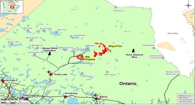
Figure 1:Location, TPK property, northwestern Ontario.
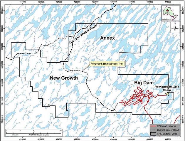
Figure 2:Current outline of the TPK property, highlighting: a) management areas (Big Dam, New Growth, Annex); b) location of the year round camp; c) established trail system to key targets defined in the Big Dam management area; and d) proposed access trail to the established east-west winter road.
“gold grain anomalies of this scale are amalgamated responses from a cluster of gold zones, they normally indicate a large gold system or district rather than a single gold zone” (see Northern Superior Press Release, June 21, 2010).
Mineralization Potential
The TPK property is in a structurally favourable geological setting where the Archean-aged Bartman Lake Greenstone Belt lies adjacent to a major bend in the regional scale Stull-Wunnummin Fault (Figure 3). The Property has been intruded by the 15 km long Freure Lake Batholith. A gold grain-in-till anomaly extends southwest from the southern edge of the batholith, suggesting that the associated bend in the Stull-Wunnummin Fault propagated a series of gold-bearing splay shears, concentrated along the southern margin of the structurally resistant buttress formed by the batholith. This metallogenic model is an analogous to that for the Malartic-Val d’Or gold district in Québec, where gold deposits are controlled by splay shears related to a major bend in the Larder Lake-Cadillac Fault and is hosted by the synvolcanic Bourlamaque Batholith and several smaller granitoid and porphyry stocks.
Big Dam Management Area (eastern area of the property)
Reverse circulation drilling and surface till sampling completed over this area of the TPK property:
- Identified a 6 x 11 km gold grain-in-till dispersal apron: with till samples returning up to 1,221 pristine gold grains (Figure 4): 10 grains from a 10 kg sample is considered highly anomalous.
- Regarded as one of the largest such aprons in North America and probably the largest if it extends almost 32 km across the property as Northern Superior suspects.
- Key fact to take away from this remarkable and unique geological feature is that it is impossible to get so many gold grains in the surface environment unless there is significant visible gold exposed at the bedrock surface for glacial ice to erode, transport and deposit.
- Discovery of key resources are inevitably discovered by tracing these dispersals to source. Examples of recent such discoveries are highlighted in the Corporate presentation located on this website (see Corporate Presentation, Northern Superior Resources Inc. web site www.nsuperior.com, Investor Centre): a) Agnico Eagle’s Meliadine (Nunavut) deposit; b) TMAC Resources Naartok (Nunavut) deposit; and c) New Gold’s Blackwater Creek (British Columbia) deposit.
To repeat from the opening page of this summary:
“gold grain anomalies of this scale are an amalgamated response from a cluster of gold zones which normally indicate a large gold district rather than a single zone” (see Northern Superior Resources Inc. press release, June 21, 2010).
The importance of predominately pristine gold grains within a gold grain concentrate from a till sample cannot be emphasized enough. The rule of thumb is that as gold, being very malleable, its original pristine wire- like shape is transformed to a “modified” form within 200 m from its source rock (see Corporate Presentation, Northern Superior Resources Inc. website www.nsuperior.com, “Investors” section).
The importance of the gold grain-in-till dispersal apron is accentuated by the presence of several gold and silver- bearing boulder trains embedded within the apron (Figure 5), returning assay values of up to 94.2 g/t Au. It important to note that:
- Assay values are superior to those determined from boulder dispersal trains associated with the Meliadine deposit(s) (see Northern Superior Resources Inc. press release, November 8th, 2017); and
- The head of these trains identify compelling mineral targets for both gold and silver (see Northern Superior Resources Inc. press release, November 8th, 2017).
- To date, diamond drilling has intersected up to 25.9 g/t gold over 13.5m within shear-zone hosted quartz veins. Notably, this was based on a low-priority target away from the core of the till dispersal apron, which has yet to be tested by drilling.
Annex Management Area (north-central area of the property)
Till sampling has identified a 3.5 x 10 km gold-in-till dispersal corridor (Figure 6)(Keely Lake gold grain-in-till dispersal corridor, see Northern Superior Resources Inc. press release, December 11, 2011):
- Till sampling and prospecting completed during 2017 successfully provided an up-ice cut-off for this corridor
- This gold grain-in-till corridor extends up to, and terminates at, a greenstone belt;
- Till samples have returned up to 1,690 pristine gold grains (see Northern Superior Resources Inc. press release, December 6, 2017).
Various prospecting programs (see Northern Superior Resources Inc. press releases, December 7, 2011; October 11, 2017) defined:
- Several mineralized boulders trains embedded within the head of the Keely Lake gold grain-in-till dispersal corridor (see Figure 7);
- Mineralized boulders returning assay values as high as 727 g/t gold, 111 g/t silver and 4.05% copper, these boulder trains;
- These assays consist of values superior to those determined from boulder dispersal trains associated with the Meliadine deposit(s) (see Northern Superior Resources Inc. press release, October 11, 2017); and
- Compelling mineral targets at the heads of these trains for gold, silver and copper (see Northern Superior Resources Inc. press release, October 11, 2017).
Limited diamond drilling in the area during 2012 intersected shear zones between felsic and mafic volcanics, which returned anomalous gold values, including 41.5 g/t over 0.6m.
New Growth Management Area (western area of the property)
The gold grain-in-till dispersal apron clearly defined within the Big Dam management area is thought to extend west another 24 km into the New Growth management area as defined by:
- Continuation of a major structure as defined by airborne geophysics;
- Dispersal of arsenic geochemistry from that same structure as defined by the geophysics (Figure 8; and
- Anomalous gold grain-in-till signatures, again emanating from that same structure.
Like the Annex management area, New Growth also has the potential to host gold, silver and copper:
- Highlighted by a 30+ cm wide bornite-chalcopyrite bearing quartz vein hosted in locally derived, moderately to strongly sheared monzonite boulder; and
- Returned values of 12.60 g/t gold, 111 g/t silver, and 4.05% copper (see Photo 1).
- Fourteen high priority drill targets are defined by a structural study completed from the Company’s proprietary airborne geophysical data (see Corporate presentation, Northern Superior Resources Inc. web site www.nsuperior.com, “Investor Center”), never prospected, never drilled.

Figure 3:The TPK property with the current understanding of the regional geology. Mineralization appears to be structurally controlled, analogous to that of the Malartic-Val d’Or gold district in Québec.

Figure 4:The Big Dam gold grain-in-till dispersal apron. A unique geological feature, representing one of, if not the largest such dispersal of gold in North America.

Figure 5:Distribution of gold and silver- bearing boulders, Big Dam area.

Figure 6:Keely Lake gold grain-in-till dispersal corridor.

Figure 7:Distribution of gold, silver and copper- bearing boulders, Annex area.

Figure 8:Extension of the gold grain-in-till apron west onto the New Growth management area is clearly depicted by: a) extension of the gold-bearing shear zone as illustrated by airborne geophysics; b) anomalous gold grain-in-till values down-ice of this shear zone; and c) elevated arsenic values in till down- ice of this shear zone as illustrated in this Figure (reds and yellows).

Photo 1:This quartz vein collected from the New Growth management area returned values of 12.60 g/t gold, 111 g/t silver, and 4.05% copper.
Prospecting on the newly discovered greenstone belt recovered 100 sheared and/ or mineralized boulders and outcrop samples of which 83 were anomalous- assaying as high as 727 g/ t gold, 111 g/ t Silver and 4.05% Copper.
2017 Work Program
During Q3 2017, Northern Superior Resources completed a multi-disciplinary mineral exploration program over the Big Dam and Annex management areas of the property, key highlights include:
- Prospecting and boulder sampling over the Annex management area, 191 boulder samples collected;
- Prospecting and boulder sampling over the Big Dam management area, 251 boulder samples collected;
- Bulk till heavy mineral sampling over the Annex management area, 290 till samples collected;
- Re-logging of historic core (9 holes 2,373m +18 samples for assay) from the Big Dam management area, completed primarily to re-evaluate geologic controls on gold mineralization, complimented by a petrographic study and new 3D modelling of drill-holes and structures;
- Repairs and up-grades to the Rowlandson Lake Exploration Camp in preparation for up-coming core drill programs were also completed;
- Results from the 2017 exploration programs were assimilated into the Company’s comprehensive geoscientific data base for the property and from this, mineral targets were redefined within 5 distinct areas within the Big Dam management area (Figure 9).

Figure 9: Five high priority areas within which specific mineral targets have been identified, Big Dam management area.
2019 Exploration Plans
The heavy lifting on the property is now complete. We have defined several high priority targets. A sustained core drill program is now required. The Company is currently seeking a strategic partner to assist on moving exploration forward on the property.
Source: http://www.nsuperior.com/Projects/tpk.aspx

|