Greenstone Gold Mines GP Inc.
Viper Property
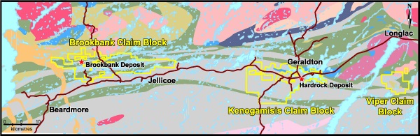
1.1 General
The Viper Property is a contiguous block of 17 mining claims located in the Thunder Bay Mining Division. The property covers a total approximate area of 3,410 hectares and is located in the McBean Lake Area Township. The Property is not subject to any royalties and is 100% owned by Greenstone Gold Mines GP Inc.
1.2 Location
The property is situated in the Thunder Bay Mining Division of Ontario, with all claims located on the NTS sheets 42 E/10 and 42 E/11. The property is located approximately 300 kilometres northeast of the city of Thunder Bay, Ontario and approximately 11 kilometres south of the town of Longlac. The city of Thunder Bay has a population of 110,000 and provides support services, equipment and skilled labour for both the mineral exploration and mining industry. Rail, national highway, port and international airport services are also available out of Thunder Bay. The Municipality of Greenstone and surrounding communities can provide supports services, equipment and skilled labour for both the mineral exploration and mining industry.
1.3 Project Size and Ownership
Greenstone Gold Mine GP Inc.’s Viper Property is a contiguous block of 17 mining claims. The property covers a total approximate area of 3,410 hectares and is located in the McBean Lake Area Township. The Property is not subject to any royalties and is 100% owned by Greenstone Gold Mines GP Inc.
1.4 Viper Property Geology
The Viper Property resides in a location of the Beardmore-Geraldton Greenstone Belt where the Central Meta-Volcanic Unit and the Southern Meta-Sedimentary Unit are strong folded together. This folding pattern closely resembles the same refolding that is found in the Hardrock Property area. The central meta-volcanic unit is comprised of massive and pillowed basalts and andesite with mid-ocean ridge basalt geochemical affinity, interlayered with thin sedimentary and tuffaceous beds. The central meta-volcanic unit differs from the southern meta-volcanic unit by thicker deposits of pyroclastic rocks and an abundance of large amygdules in the flow rocks, suggesting shallow-water or subaerial volcanism (Kresz and Zayachivsky 1991). The majority of the flow rocks are andesites and dacites of calc-alkaline affinity with trace and rare-earth element patterns suggesting deposition in an emergent volcanic arc above a subduction zone (Tomlinson et al. 1996). There are also numerous young diabase dykes running roughly north-south crosscutting all other rocks. The southern meta-sedimentary unit is comprised of clastic and chemical sedimentary rocks.
Polymictic conglomerate occurs as thin horizons (<5m) within a thick sequence of thinly to thickly bedded feldspathic sandstone interlayered with thinly bedded siltstone and argillite. Banded iron formation, a minor component of the unit, occurs as fine magnetite-rich laminae and jasper-hematite beds within 3-30m thick horizons interlayered with thinly bedded green argillite, siltstone and sandstone. In the middle of the folded southern meta-sedimentary unit there is a large felsic porphyry plug. The felsic porphyry body is folded and is only slightly younger than the surrounding clastic meta-sediments.
Source: https://www.greenstonegoldmines.com/article/viper-property-150.asp
