TORONTO, Sept. 17, 2020 (GLOBE NEWSWIRE) -- Alamos Gold Inc. (TSX:AGI; NYSE:AGI) (“Alamos” or the “Company”) today reported new results from surface exploration drilling at the Island Gold Mine, further extending high-grade gold mineralization down-plunge in Island East. All reported drill widths are true width of the mineralized zones, unless otherwise stated.
• Island East: high-grade gold mineralization extended up to 100 metres (“m”) down-plunge from the nearest Inferred Mineral Resource block over significantly greater widths. The two new intersections indicate the zone has widened in this area with true widths three to four times greater than the 5.3 m average width of the large Inferred Mineral Resource block up-plunge (719,800 ounces grading 18.74 grams per tonne of gold (“g/t Au”) (1.2 million tonnes) as of December 31, 2019). New highlights include:
• 28.97 g/t Au (26.89 g/t cut) over 21.76 m (MH25-04); and
• 15.38 g/t Au (14.19 g/t cut) over 15.02 m (MH25-03).
Note: Drillhole composite intervals reported as “cut” may include higher grade samples which have been cut to 160 g/t Au for Island East Area.
“These new high-grade results over much greater widths include the best surface exploration hole ever drilled at Island Gold and further extend mineralization from one of the highest grade portions of the ore body. They not only demonstrate the significant potential for additional growth in Mineral Reserves and Resources but further validate our decision to install a shaft as part of the Phase III Expansion,” said John A. McCluskey, President and Chief Executive Officer.
2020 Surface Exploration Drilling Program – Island Gold Mine
Exploration activities at Island Gold remain focused on continuing to define new near mine Mineral Resources and building on the success of the 2019 drilling program. After being temporarily suspended on March 25, 2020, due to the COVID-19 pandemic, the surface directional diamond drilling program resumed in early June with three drill rigs currently drilling.
A total of 16,660 m of surface directional diamond drilling has been completed as of September 15, 2020. New highlight intercepts can be found in Table 1 and in Figures 1 and 2, at the end of this news release.
Island East
Surface directional drilling continues to extend gold mineralization with drill hole spacing ranging from 50 m to 100 m (Figures 1 and 2).
New highlights from the surface drilling program include (E1E-Zone) (Table 1):
-
28.97 g/t Au (26.89 g/t cut) over 21.76 m (MH25-04); and
-
15.38 g/t Au (14.19 g/t cut) over 15.02 m (MH25-03).
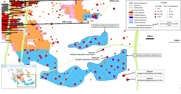
Drillholes MH25-03 and MH25-04 intersected wide, high-grade gold mineralization 40 m and 100 m, respectively down-plunge from the high-grade Inferred Mineral Resource block which contained 719,800 ounces, grading 18.74 g/t Au (1.2 million tonnes) as of December 31, 2019. These intercepts have true widths approximately three to four times greater than the 5.3 m average width of this Inferred Mineral Resource block indicating the zone has widened in the area of these holes. Using the cut weighted gold grade for metal factor calculation, drillhole MH25-04 is the best surface directional hole drilled to date at Island Gold in terms of gold content for a drill hole intersect.
As previously reported on July 13, 2020, drillholes 620-MH2-01 (29.05 g/t Au (26.67 g/t cut) over 4.86 m) and MH21-04 (44.30 g/t Au (44.30 g/t cut) over 2.25m) have also extended high-grade mineralization up-plunge from this Inferred Mineral Resource block within the 120 m gap between the middle and lower portion of Island East. Both areas will continue to be an exploration focus for the remainder of the year with the deposit open laterally, up- and down-plunge.
These results continue to confirm the E1E Zone extends vertically over 1.2 km, between a depth of 300 m and 1,500 m in the eastern part of the deposit.
About Alamos
Alamos is a Canadian-based intermediate gold producer with diversified production from three operating mines in North America. This includes the Young-Davidson and Island Gold mines in northern Ontario, Canada and the Mulatos mine in Sonora State, Mexico. Additionally, the Company has a significant portfolio of development stage projects in Canada, Mexico, Turkey, and the United States. Alamos employs more than 1,700 people and is committed to the highest standards of sustainable development. The Company’s shares are traded on the TSX and NYSE under the symbol “AGI”.
FOR FURTHER INFORMATION, PLEASE CONTACT:
Scott K. Parsons
Vice President, Investor Relations
(416) 368-9932 x 5439
Table 1: Island Gold – Previously Unreleased Select Composite Intervals from Surface Exploration Drilling
Composite intervals greater than 3 g/t Au weighted average, capping values @ 160 g/t Au.
Table 2: Surface exploration drill holes; azimuth, dip, drilled length, and collar location at surface (UTM NAD83)
Figure 1: Island Gold Mine Longitudinal
Figure 2: Island Gold Mine East Area – Surface Directional Drilling Results