Moneta Porcupine Mines Inc.
MONETA CONFIRMS EXTENSIONS OF NEW SOUTH BASIN TARGET WITH 2.20 M @ 15.76 g/t GOLD including 0.60 M @ 39.60 g/t GOLD
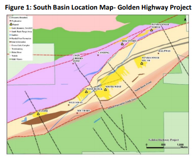
Toronto, Ontario – September 03, 2020 - Moneta Porcupine Mines Inc. (TSX:ME) (OTC:MPUCF) (XETRA:MOP) (“Moneta” or the “Company”) is pleased to announce the results from historical drilling along the new South Basin trend, including the South BIF target, on the Company’s Golden Highway Project, 110 km east of Timmins, Ontario (Figure 1).
Highlights:
Historical drilling along the new South Basin trend on the southern margins of the regionalsedimentary basin has confirmed significant gold mineralization:
• MSW10-270: Intersected 2.20 metres “m” @ 15.76 grams per tonne “g/t” including 0.60 m @ 39.63 g/t Au
• MSW10-267: Intersected 7.09 m @ 2.76 g/t Au including 1.00 m @ 6.79 g/t Au
• MGH18-093: Intersected 3.00 m @ 3.28 g/t Au including 1.00 m @ 7.03 g/t Au
• MGH18-093A: Intersected 10.00 m @ 2.11 g/t Au including 1.00 m @ 4.46 g/t Au
• Historical drilling has confirmed gold mineralized veins over 1.2 kilometre “Km” of strike length, east of South BIF along the South Basin trend
“We are excited to have discovered additional significant gold mineralization results on the South Basin trend from historical drilling.”, commented CEO, Gary O’Connor “We have intersected mineralized gold veins over 1.2 km of strike length on the southern margins of the basin east of the recently recognized favourable BIF A host contact in numerous historical drill holes. The gold occurs south of and as possible extensions of the Westaway/West Block and South West gold deposits. The assay results are from previously un-released assays which have not been used for historical resource estimates. The South Basin represents a new regional trend of prospective ground at the Golden Highway Project where no systematic exploration has been conducted previously. We look forward to exploring the trend further.”
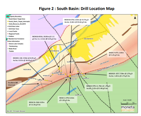
The latest assay results are from ten (10) historical drill holes completed along the South Basin contact, and drill hole MGH20-148 which was drilled at the South BIF target in the recent winter 2019/2020 drill program. MGH20-148 successfully intersected significant mineralization adjacent to an occurrence of the favourable BIF A on the southern margins of the basin (see press release ME PR 09-2020 dated May 21, 2020; Drilling intersected 3.50 m @ 8.09 g/t Au, including 0.55 m @ 30.40 g/t Au). This prompted a review of the 10 historical drill holes which had tested the newly recognized trend. The drill assay intercepts from historical holes were not previously included in any historical resource estimate and represent a new mineralized trend.
South Basin Drill Results
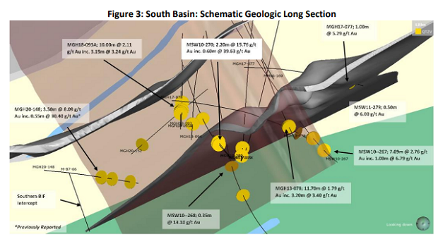
The ten (10) historical drill holes reviewed were drilled over more than 1.2 km of strike length along the southern contact of the Timiskaming sedimentary basin primarily to test the depth extensions of the South West deposit located to the north. The newly recognized gold mineralization was intersected at shallower depths near the southern contact of the basin with the Lower Blake River mafic volcanic unit. The gold assay results intersected along the South Basin contact have not been included in any historical resource estimate and are now recognized to be new mineralized zones located in the same geological setting as the gold mineralization intersected recently in drill hole MGH20-148.
Please click on the link shown here for a complete table of all drill results.
https://www.monetaporcupine.com/south-basin/
Drill hole MGH20-148 was drilled to test a section of the favourable coarse grain sandstone host located adjacent to a newly recognized occurrence of the regional BIF A unit intersected in historical hole M87-66. MGH20-148 intersected up to 3.50 m @ 8.09 g/t Au, including 3.00 m @ 9.22 g/t Au, including 0.55 m @ 30.40 g/t Au confirming well mineralized veining in an area not previously recognized as having significant gold potential. The ten (10) historical holes which tested the area close to the south contact of the basin also intersected significant gold intersections (Table 1). The south basin contact is 12 km long on the Golden Highway Project and has only been subjected to drilling over a 1.2 km strike length to date. Other significant intercepts from historical drilling included 2.20 m @ 15.76 g/t Au including 1.20 m @ 25.97 g/t Au including 0.60 m @ 39.63 g/t Au from drill hole MSW10-270, and 3.00 m @ 3.28 g/t Au including 1.00 m @ 7.03 g/t Au from drill hole MGH18-093. Drill hole MSW10-267 intersected 7.09 m @ 2.76 g/t Au including 1.00 m @ 6.79 g/t Au, and MGH17-093A intersected 10.00m @ 2.11 g/t Au including 1. 00 m @ 4.46 g/t Au. Drill hole MGH13-078 intersected 11.70 m @ 1.79 g/t Au including 3.20 m @ 3.40 g/t Au.
South Basin Trend
The South Basin trend is located along the southern margins of the regional Timiskaming sedimentary basin where a repeat occurrence of the prospective coarse sandstone sediment located adjacent to the BIF A unit has recently been discovered. The majority of Moneta’s current mineral resources are hosted on the north limb of this regional syncline to the north. The geological setting is similar to the South West deposit located to the north (Figure 1) and mineralization is seen to occur as a series of mineralized vein structures. The gold mineralized quartz-pyrite veins within the South Basin trend are associated with ankerite-sericite-silica-pyrite alteration haloes. The zones occur as steeply west dipping WNW-ESE
oriented mineralized structures as per the main mineralization at South West and Westaway/West Block. The southern basin margin has not been systematically explored historically and represents a major new regional prospective trend.
About Moneta
The Company holds a 100% interest in 6 core gold projects strategically located along the Destor-Porcupine Fault Zone in the Timmins Gold Camp with over 85 million ounces of past gold production. The projects consist of the Golden Highway, North Tisdale, Nighthawk Lake, DeSantis East, Kayorum and Denton projects. The Golden Highway Project covers 12 kilometres of prospective ground along the DPFZ of which 4 km hosts the current 43-101 mineral resource estimate comprised of an indicated resource of 556,500 ounces gold contained within 3.82 Mt @ 4.53 g/t Au and a total of 1,174,000 ounces gold contained within 8.47 Mt @ 4.31 g/t Au in the inferred category at a 3.00 g/t Au cut-off. A preliminary economic assessment on the South West deposit located within the Golden Highway Project commenced in Q1, 2020. The results of the PEA are due to be delivered this quarter. The study will review several development scenarios for the South West deposit which was the subject of a resource update in November 2019.
FOR FURTHER INFORMATION, PLEASE CONTACT:
Gary V. O’Connor, CEO
416-357-3319
Linda Armstrong, Investor Relations
647-456-9223
Source: https://www.monetaporcupine.com/uploads/2020-09-03-NR-ME.pdf

|