Orefinders Resources Inc
Orefinders Completes Ground Geophysical Survey and Initial Modeling at McGarry Gold Project
Toronto, Ontario – June 11, 2021 – Orefinders Resources Inc. ("Orefinders" or the "Company") (TSX.V: ORX) is pleased to announce the completion of a DCIP-MT ORION SWATH ground-based Geophysical Survey (“Survey”) on its McGarry Gold Project (“McGarry”). McGarry is adjacent to the Kerr Addison Mine that produced approximately 11 million ounces of gold before closing in 1996.
The initial 2-D modeling of the Survey data has shown significant IP (Induced Polarization) and MT (Magnetotelluric) anomalies associated with the Larder-Cadillac Fault Zone between the McGarry headframe and the Barber-Larder open-pit and also at other less explored target areas at McGarry (Figure 1).
“This sort of survey, combining quasi 3-D IP and deep-penetrating MT technologies has never been conducted on McGarry. This approach is aimed at delineating new exploration drill targets that could lead to new gold discoveries on a highly prospective project along the Larder-Cadillac Fault Zone,” said Keith Benn, Orefinders Vice President of Exploration.
The Survey was designed to gather high-resolution data at depth that will be key to identifying ‘under cover’ exploration targets, i.e., potential ore bodies that do not reach the surface. Subsequent 3-D modeling of this geophysical data set along with machine learning applied to all available data for McGarry will allow the Company to prioritize exploration targets for a drilling program later in 2021.
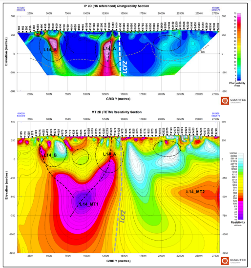
Figure 1. Cross-sections along ORION SWATH survey line 1400 at McGarry showing 2-D models of IP Chargeability (top panel) and MT Resistivity (bottom panel) generated by Quantec Geoscience. Horizontal and vertical scales are the same for the two images although the MT section continues to greater depth. Hot colours in the IP model indicate high chargeability. Hot colours in the MT model indicate lower resistivity (i.e., electrically conductive) rocks whereas cooler colours indicate more highly resistive rocks. The white dash trace in the upper panel is Mistango's interpretation of the Larder-Cadillac Fault Zone (LCFZ) which is shown as a grey dash trace in the lower panel. The black dash ovals labeled L14_A and L14_B indicate areas of interest for exploration where high chargeability anomalies might indicate the presence of sulphide mineral concentrations spatially coinciding with relatively resistive areas that might indicate the presence of abundant silica alteration and/or quartz veining. The black dash traces indicate potential continuity of anomalies that might indicate the presence of fault structures that would be spatially associated with mineralization.
About Orefinders Resources Inc.
Orefinders is a Gold exploration and development company focused exclusively on the Abitibi Greenstone Belt. The Company is listed on the Toronto Venture Exchange under the symbol ORX.
Source: https://orefinders.ca/news/orefinders-completes-ground-geophysical-survey-and-initial-modeling-at-mcgarry-gold-project/

|
Geologist
If you are a geologist and interested in working with a dynamic team in the Kirkland Lake area, please send your resume and cover letter to careers@oregroup.ca