UKKO Canada
Aerial Imaging Drones
Aerial Imaging Drones For Professional Applications
Essential Tools for Surveying, Mapping, and Precision Agriculture.
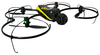
Meet eXom, the sensor-rich drone for professionals, offering TripleView imaging and advanced situational awareness.
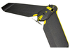
Capture aerial photography to produce orthomosaics & 3D models with absolute accuracy of down to 3 cm – without Ground Control Points.
Use this fully autonomous drone to capture high-resolution aerial photos that you can transform into accurate 2D orthomosaics & 3D models.

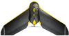
The eBee Ag is the only precision farming UAV you need. With its full drone-to-tractor workflow you can scout your crops, analyse plant health, create prescriptions and begin treatment all on the same day.