Galleon Gold hits more high grade at West Cache near Timmins

Galleon Gold Corp. continues to intersect significant gold grades in all three target areas at its 100% - owned West Cache Gold Project, Timmins.
Select Highlights:
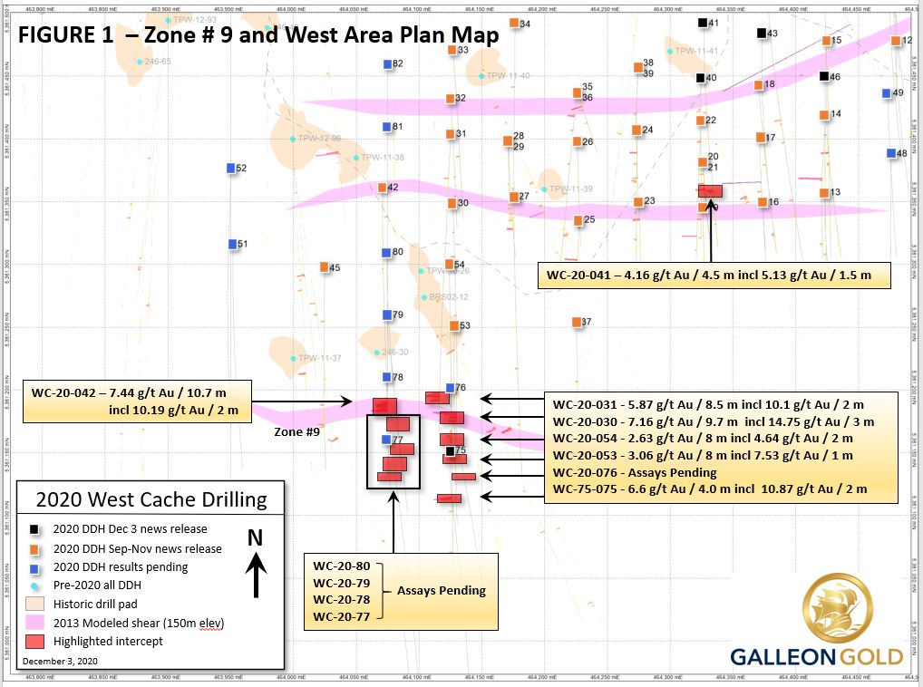
- WC-20-075 intersected 6.6 g/t Au over 4.0 m, from 54 to 58 m including sub-interval of 10.87 g/t Au over 2.0 m; near surface intercept of Zone-9.
- WC-20-072 intersected 3.27 g/t Au over 5.2 m, from 144 to 149.2 m including sub-interval of 9.4 g/t Au over 1 m; West Area intercept.
- WC-20-041 intersected 4.16 g/t Au over 4.5 m, from 241.5 to 246 m; East Area intercept.
Current Drill Plan
With two drills now deployed on the property, one drill is exclusively focused on Zone #9, while a second drill rig is working to delineate near surface gold mineralization in the East Pit area.
Zone #9 drilling is focused on completing a north-south fence of drillholes located 50 meters west of the initial discovery area, where five-holes have traced the mineralization from seven meters below the bedrock interface to a depth of 165 meters. Figure 1 provides an updated plan map and identifies recent mineralized intercepts. As grade continuity and thickness continue to be defined with the ongoing Zone #9 drilling, similar near surface targets will be drill tested along strike to the east and west. The Company's geologists continue to gain insight into the possible link between the distinct geologic features characterizing the recent near surface Zone #9 gold mineralization and similar high-grade sediment hosted mineralization encountered in historic drilling approximately 500 meters downdip to the northwest.

Figure 1
To view an enhanced version of Figure 1, please visit:
https://orders.newsfilecorp.com/files/1014/69397_28d72fa3642588a4_001full.jpg
The second drill rig is completing infill drilling of the contemplated East Pit area and related deeper extensions as discussed in recent Company news releases. The latest results continue to confirm the continuity and grade of the mineralized shear zones from the bedrock interface to vertical depths of several hundred meters.
Data from both Zone #9 and the infill pit areas will be included in the Preliminary Economic Assessment ("PEA"), targeted to be published by early April 2021. Upon completion of the infill drill program, the second drill will shift to Zone #9 for additional exploration along strike and dip.
Figure 2 presents core photos showing the sediment-hosted mineralization typically encountered in Zone #9. Table 1 outlines select results from three holes, including one in each of the three target areas. A full compilation of assays over 1 g/t Au are published on the Company's website.

Figure 2
Tags: Northern Ontario / Exploration / Gold / All Articles