Golden Goliath Discovers Favourable Uchi Rocks on West Grid Southern trend on Kwai Project, Red Lake

Golden Goliath Resources Ltd. has completed four drill holes on the southern trend of IP anomalies on the West Grid of its Kwai Project (Figure 2). These four holes (K20-11 to K20-14) have discovered a large cross section over 400m wide of Uchi basalt and porphyry rocks originally thought to be English River metasediments and gneisses. This discovery is significant in that the Uchi rocks are the main hosts for the Red Lake gold mines and now we can see that a large part of the Kwai property contains an extensive belt of these favourable rocks, which expands our target areas across the property.

Figure 1: Red Lake District Properties including the Kwai and SLF properties of Golden Goliath
To view an enhanced version of Figure 1, please visit:
https://orders.newsfilecorp.com/files/4761/69336_7e56401a7453b9b1_002full.jpg
The three trends of IP anomalies on the southern portion of the West Grid have only been drilled on two lines 0+00 and 200E, with two holes on each line (Figure 2). These IP trends continue to line 10 west, or one kilometer. These targets remain untested as do the additional numerous IP trends that occur on the eastern grid. The Company is awaiting assays for the completed drill holes before further drilling.
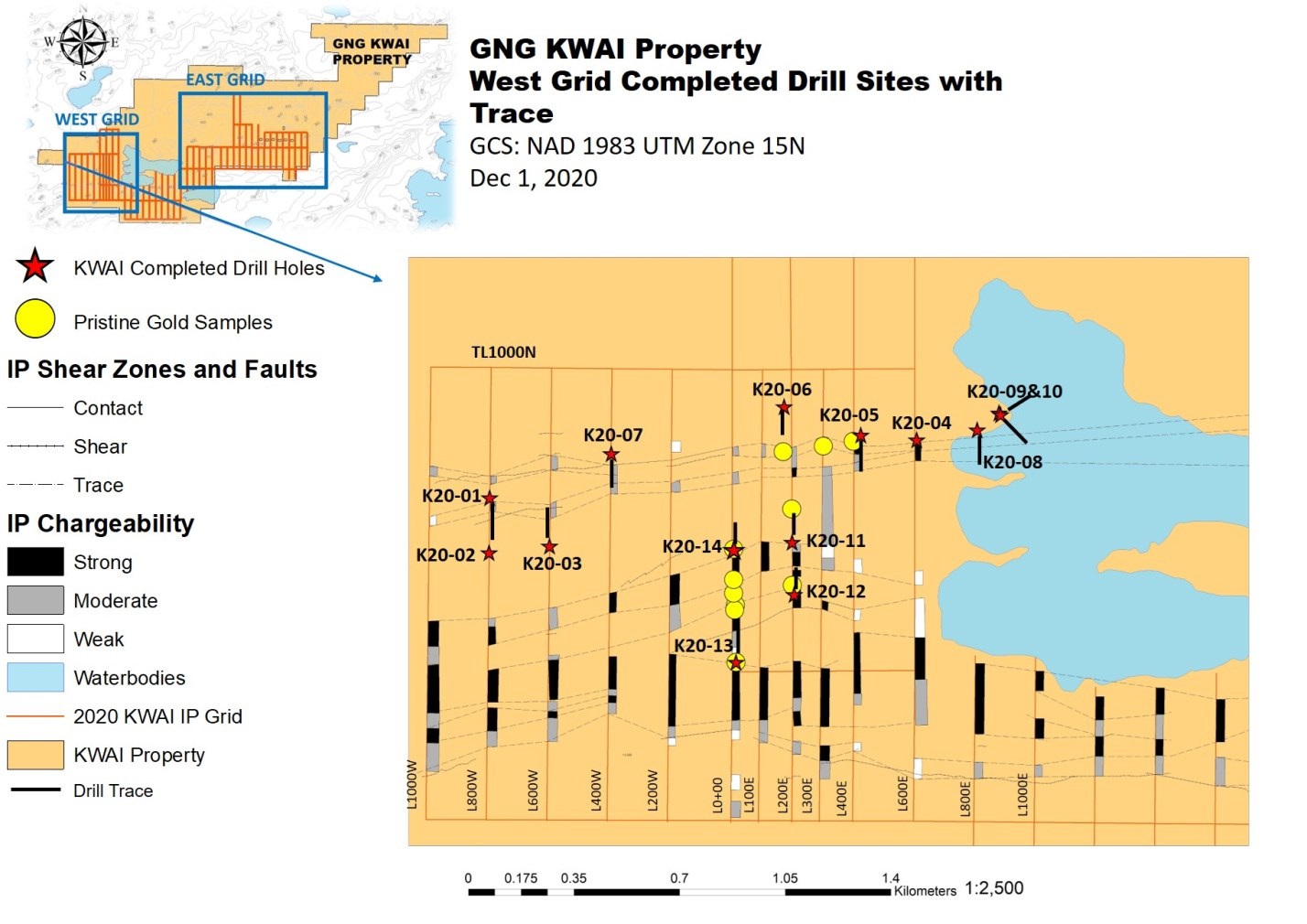
Figure 2 West Grid showing IP anomaly trends and completed drill holes
To view an enhanced version of Figure 2, please visit:
https://orders.newsfilecorp.com/files/4761/69336_7e56401a7453b9b1_003full.jpg
The boundary of the English River Sub Province is complicated by the occurrence of both major deep seated faults and associated splay and parallel faults which are potential controlling structures for gold mineralization. These faults appear to have repeated the Uchi sequence by possible thrusting although folding has not been ruled out. A section of the line 200E area is presented to show the position of these major rock units (Figure 3).

Figure 3: North-South Cross Section on West Grid Showing Uchi Rocks on Southern
To view an enhanced version of Figure 3, please visit:
https://orders.newsfilecorp.com/files/4761/69336_7e56401a7453b9b1_004full.jpg
Trend of IP Anomalies
Gold grains found in basal till samples on the West Grid may have originated from Uchi rocks further east along the Pakwash Fault trend, where numerous IP anomalies occur, or from the area of Beauregard Lake as shown in Figure 4. A variety of drill targets based on existing IP results interpreted to be caused by disseminated sulphide zones are present across the eastern 2/3 of the property. There are also at least two more mag-interpreted splays cutting the main Pakwash break on the East Grid, similar to the one that occurs under Beauregard Lake. The Company is now organizing a winter IP survey over the lake, which has numerous intersecting spay and extensional faults. The lake area is the primary source area for the gold grains on the West Grid based on dispersion distance and ice directions (figure 4).

Figure 4 Compilation Showing Gold Grains, Possible Source Area For West Grid Grains, IP Trends and Major Structures
To view an enhanced version of Figure 4, please visit:
https://orders.newsfilecorp.com/files/4761/69336_7e56401a7453b9b1_005full.jpg
The access road to the East Grid, which also allows access to the Central Grid south of Beauregard Lake, both of which host gold grains and IP drill targets, is scheduled to be completed by December 15th.
CEO Paul Sorbara comments: "We have learned a lot in the first few months of drilling, having started with a property with very little exploration, no real mapping and no drilling. Now we know we have the right structures, lithologies and alteration types. There is a lot more to do. The source of the numerous gold grains in the basal till on the West Grid and across the property is not far away and they probably come from at least two different sources. We intend to find out where. The East Grid is undrilled so far and we are planning to quickly do IP on the lake and the splay fault to the northwest of the lake, both of which fall within the probable source area for the gold grains on the West Grid."
Tags: Northern Ontario / Exploration / Gold / All Articles