Northern Gold Mining Inc.
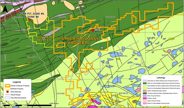
Harker-Holloway Property
The Harker-Holloway Claim Group is contiguous with the Buffonta Mine Group to the west and extends north-easterly across Harker, Holloway and Marriot Townships in north eastern Ontario; the claim group also extends south into Elliot, Tannahill and Clifford Townships. The Harker-Holloway claim group is comprised of a contiguous block of 276 staked mining claims, 3 mining leases and 15 patented mining claims totalling 12575 hectares.
Highlights
• The Iris deposit boasts a historic gold/tungsten resource with expansion potential both along strike and at depth
• Existing 500ft surface decline with potential for resource development
• Extensive land package with very little historical exploration covering 27 kilometers along the strike horizon of the Iris deposit
• Potential for the discovery of both bulk tonnage low grade gold/tungsten deposits as well as high grade deposits
• General Geology1
The Harker-Holloway property is underlain by Archean supracrustal rocks of the Lower Blake River assemblage along most of its north-easterly strike length and the south properties extend across rock formations of the Upper Blake River assemblage. The rock is predominantly comprised of magnesium to iron-rich tholeiitic basalt with low grade metamorphic alteration. Lesser amounts of wacke sediments and rhyolite occur within the stratigraphic section and locally intrusions of syenite, granite, monzonite and pyroxenite are found.
The rock sequence covered by the property measures 27 kilometers along the upper most strata in the Lower Blake River assemblage. These rocks form part of the north limb of the Blake River Basin, a broad synclinorium which is defined on the north by the Destor-Porcupine Fault Complex and on the south by the Larder-Cadillac Fault Complex. Structurally the Lower Blake River assemblage in the project area is homoclinal and characterized by east-northeast striking and southerly dipping rock units. Derivatives of regional magnetics clearly indicate the regional stratigraphy within the project area as show in figure 1.
The geology at the Iris gold/tungsten deposit is comprised variably magnetic tholeiitic basalt. Intercalated with the basalt are locally important siliceous horizons thought to be Rhyolite. In the area of the deposit, a complex, roughly ellipsoidal intrusive assemblage outcrops. It is divided into and early pyroxenitic fraction, and a later, more extensive syenitic phase. All rocks are cross-cut by north to north-easterly striking shears of variable inclination ranging from nearly flat to 80°.
Mineralization2
All of the gold mineralization discovered to date on the Iris property is associated with three main geological environments:
• Disseminated pyrite distributed throughout the crystal interstices of the syenite intrusion.
• Disseminated sulphides (mainly pyrite) associated with the north-northeaster trending shear and/or alteration zones and associated subsidiary structures.
• Disseminated pyrite, chalcopyrite, galena and sheelite with flat lying quartz veins cutting the basalt and syenite.
The disseminated pyrite mineralization in the syenite forms a series of regular pancake shaped masses of roughly 125 meters long by 90 meters wide and up to 15 meters in thickness. These zones are characterized by about 3-8% disseminated pyrite usually occupying the interstices between large alkali feldspar crystals. The pyrite appears to form an antipathetic relationship with disseminated hematite found in the same environment. The syenite – normally a brick red colour – becomes salmon pink in colour (silicified) and contains numerous fine stringers, veinlets and interstitial dissemination of white quartz and pyrite. Gold mineralization in this type of environment typically carries grades between 0.3 to 2.4 grams per tonne and averages 1.7 grams per tonne. There is a rough correlation between the pyrite and gold content. Some of this material has been remobilized to the shear zones significantly enhancing the gold grades to greater than 3.5 grams per tonne.
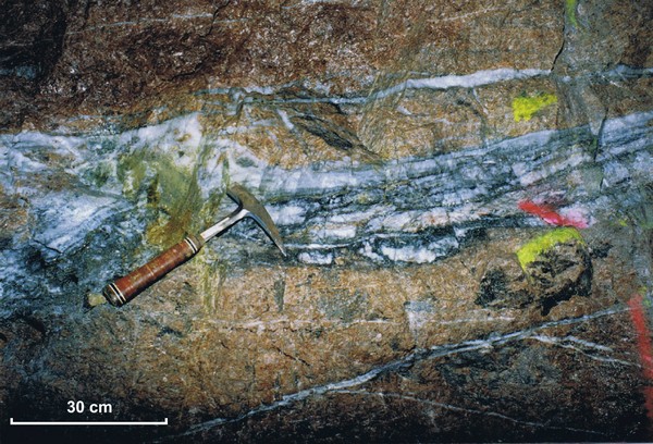
Main vein in ramp. Note presence of anastamosing dark coloured, pyrite bearing fractures and shears in vein. Scheelite often present along these fractures.
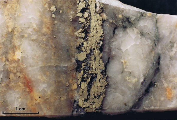
Coarse pyrite along healed fractures within gold-scheelite bearing quartz vein.
Metallurgy
A metallurgical review completed by The Alberta Gold Exploration Corporation was completed in 1989. The review summarized bench scale testwork carried out by Lakefield Research on composite drill core samples from the Iris deposit. It was concluded that good gold recovery was possible from the Iris deposit using floatation and cyanidation of the concentrate. Total gold recoveries using this method yielded an overall recovery of 92.2%.
Property History
The Harker-Holloway area was the centre of mining activity during the 1920’s when Harker Gold Mines Ltd. carried out a program of extensive underground development on their Golden Harker property.
In 1947 R. Storen examined the Iris property and reported the occurrence of gold mineralization in three separate localities associated with rhyolite interflow horizons. Three mineralized veins found on the property yielded assay results up to 9.94g/t over 0.5m, 1.37g/t over 0.2m and 3.77g/t over 0.35m respectively for veins 1,2 and 3. Between 1982 to 1985 detailed ground geophysical, geological and geochemical work along with airborne magnetic surveys were completed over the Iris claim group. This work defined a number of geophysical and geochemical anomalies.
In late 1986 and early 1987 a 1,805 meter diamond drill program was completed by Perrex Resources Inc. During 1987 The Alberta Gold Exploration Corporation became a joint venture partner and completed an ambitious program of stripping, trenching, IP surveying as well as a 5,570 meter diamond drilling program.
In 1988 an exploration program consisting of stripping, trenching, geophysical surveying, diamond drilling totalling 14,150 meters and the sinking of a 500foot (153 meter) decline was completed by The Alberta Gold Exploration Corporation. The drilling focussed on geological and geophysical targets and succeeded in outlining a complex, low grade mineralized deposit hosted by a syenite plug plus higher grade mineralization associated with a northwest trending fault zone. The mineralization within the syenite was further investigated by sinking the surface decline ramp.
While most of the historic exploration has been focussed on the Iris deposit, several regions of the land package have been historically explored through ground geophysics and limited diamond drilling.
References and Disclaimers
*All assays are historic in nature and as such do not comply with NI 43-101 requirements and therefore, should not be relied upon. All results are reported from 3rd party reports referenced above. No QP has verified the numbers and therefore they should not be relied upon.
1 Workman, A.W. 1988. An Evaluation and Reserve Estimation on Behalf of The Alberta Gold Exploration Corporation for the Iris Gold – Tungsten Deposit, Southeast Harker Township, Ontario. Al Workman and Associates.
2 Hawke, D.R. 1988. Report on the 1988 Exploration Program Iris Joint Venture Project. The Alberta Gold Exploration Corporation.
3 Hayden A.S. & Eberts D.H. 1989. Review of Metallurgical Testwork for Recovery of Gold and Tungsten from the Iris Property. The Alberta Gold Exploration Company.
4 Hawke, D.R. 1988. Mineral Reserve Estimation, Iris Joint Venture Project, Harker and Elliot Townships, Ontario. The Alberta Gold Exploration Company.
Source: http://www.northerngold.ca/golden-bear-project/harker-holloway-property
|