Taylor Project
TAYLOR
Location, Property Description and History
The Taylor Project consists of 28 wholly-owned patented claims, leases and mineral claims in the south-central part of Taylor Township covering 1,542 hectares. The property is located 53 km east of Timmins, Ontario and is easily accessible by secondary paved roads from Highways 11 and 101. The deposits are located approximately 68 km by road west of the Holt Mill. The property is centered at 529000 E and 5379000 N in NAD83, Zone 17.
Prior to the Company's acquisition of the property, the Taylor Project area was explored by Hollinger Consolidated Mines Ltd. ("Hollinger" and by a joint venture between Labrador Mining and Exploration Company Ltd success or to Hollinger and later by Esso Minerals Canada "Esso Minerals" The property includes two near surface gold deposits, the Shoot Zone and the Shaft Zone and the deeper West Porphyry Zone).
The Taylor Mine Shaft Deposit was discovered in 1962 by Hollinger who did considerable drilling from 1962 to 1966 and again from 1980 until 1984 SAS earned a 50% interest in the Taylor Project by conducting a drilling program, sinking a 172 m exploration shaft and completing an underground exploration program on the property from 1986-1988. The remaining 50% interest was acquired in 1988 from Esso Minerals# In 1991 the Company processed about 6,000 tonnes of development ore grading 2,2 g/t Au from the Shaft Deposit at the Company's then owned Stock Mill. In 1998-1999 the Company reinterpreted the geology of the Shaft Deposit and drilled additional holes into the Shaft Zone.
The West Porphyry Deposit was discovered in 1962 by Hollinger. It is located some 450 m west of the Taylor Mine Shaft Deposit. Hollinger conducted drilling in that area from 1962 through 1966 and SAS conducted significant drilling on the zone from 1986 through 1988 and again in 2004 and 2005.
The Shoot Zone was discovered by Hollinger in 1972 about 2 km west of the Taylor Mine Shaft Deposit. Hollinger drilled intermittently on the property from 1972 through 1981. In 1986 through 1997 SAS drilled intermittently on the property.
Geology, Exploration and Drilling
Four gold deposits have been defined to date along the PDFZ on the Taylor property. These are the Shaft Deposit, the Main West Porphyry Deposit, the Upper West Porphyry Deposit and the Shoot Zone. The PDFZ strikes northeast in the Shoot Zone area and curves to an almost east-west trend in the Shaft Zone area# It dips at approximately 45º to the south and overlies the Porcupine Group of metasedimentary rocks. The fault zone is typically sheared, carbonatized, peridotitic komatiites altered to talc-chlorite schist. Ultramafic volcanic rocks altered to sericitized fuchsitic green carbonate with inclusions of sericitized magnesium tholeiite volcanic rocks and altered metasedimentary rocks overlie the PDFZ in Taylor township. The site geology is discussed in the Taylor section of the October, 2006, "2006 Timmins Technical Report", prepared by Scott Wilson RPA.
As indicated above, considerable drilling has been conducted on the Taylor Project. A total of 395 diamond drill holes totaling 43,803 m were drilled on the Shaft Zone from 1962 to 1998. From 1962 to 1999, 215 diamond drill holes totaling 97,571 m were drilled in the West Porphyry area. From 1972 through 1997, 99 diamond drill holes totaling 18,223 m were drilled in the Shoot deposit area. More recently in 2006, SAS drilled an additional 10 diamond drill holes targeted to test the up-dip extension of the Main Zone.
In December 2009, the Company acquired the rights to the area that lies between the Shoot Zone to the west and the West Porphyry Zone to the east.There was no previous exploration conducted in this area in the past and was the focus of the Company's 2010 Phase I drilling program which commenced in February, 2010, see Press Release dated September 15, 2010 for summary of results. Drilling along the western portion of the Bourgeois claim intersected extensive quartz carbonate alteration similar to the Shoot Zone immediately to the west. Along the eastern margin of the Bourgeois claim, drilling intersected several wide zones of quartz carbonate alteration and quartz veining similar to that of the West Porphyry Zone. These geological results are believed to confirm the potential of the Bourgeois claim to host extensions of the Shoot and West Porphyry Zones.
A second phase of drilling commenced towards the end of 2010 with the objective to infill the resource shape to allow for higher confidence and to continue to test the areas that remain open for additional extensions of the two known zones.
Mineralization and Resources
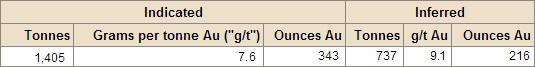
Mineral Resources at the Taylor Project are currently estimated for two areas: the West Porphyry Zone,which comprises the Main West Porphyry deposit and the Upper West Porphyry deposit, and the Shoot Zone, Mineral Resource Estimates for the Taylor Project are contained in the "2006 Timmins Technical Report", prepared by Scott Wilson RPA on October 2, 2006, and are summarized below:
Taylor Project - Mineral Resource Estimate, October 2 2006
Notes:
• Mineral Resources estimated at a cut-off grade of 4.0 g/t Au, West Porphyry, and 3.4 g/t Au, Shoot Zone, using a long term gold price of US$500 per ounce. Gold grades capped at 100.0 g/t Au.
• Tonnes and gold ounce information is rounded to the nearest thousand; rows and colums may not add exactly due to rounding.
Development and Mining
The Company's previous development program at the Taylor Project was conducted in October 2005, with the establishment of surface infrastructure and facilities and site clearing for the surface box cut for the Taylor decline ramp. The construction of a box cut and a 3,000 m decline ramp commenced in March 2006, to access the Taylor Shaft, Upper Porphyry and West Porphyry Zones for underground delineation and drilling and metallurgical testing. All necessary permits and reclamation bonds were in place for the described work.
The Taylor decline ramp was advanced a total of 1,091 m. Drill stations were established in the Main Taylor Decline Ramp and an underground drill program commenced to allow delineation drilling of mineralized areas in the Taylor Shaft, Upper Porphyry and West Porphyry Upper areas to be undertaken
as the decline advanced.
During 2007, underground workings in the Shaft zone were partly rehabilitated in order to investigate the Taylor Shaft Zone mineralization. In 2007, underground development totaled 318 m and a total of 11,938 tonnes grading 5.5 g/t Au were mined and a 8,881 tonne bulk sample was processed at the then Company owned Stock Mill and 1,357 ounces of gold were recovered. Averaged mill recovery rate was 84.7%.
In October 2007, the Taylor Project was placed on care and maintenance as a result of the focus of the Company's exploration and development activities at the Holloway-Holt Project. As of 2010, the Company has re-commenced its exploration activities on the Taylor Project as discussed above.
• Technical Report on the Taylor, Clavos, Hislop and Stock Projects in the Timmins Area, Northeastern Ontario, Canada, dated October 2, 2006 (the "2006 Timmins Technical Report").
Source: http://www.sasgoldmines.com/s/TaylorProject.asp
|