Metals Creek Resources
Tilt Cove - NFLD
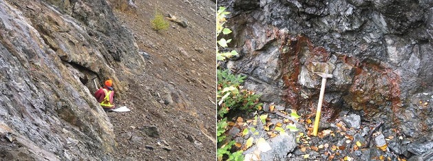
The Tilt Cove property lies on the eastern side of the Baie Verte Peninsula in northern Newfoundland. This Peninsula is host to a number of gold and base metal deposits including the Tilt Cove Mine which produced a total of 8,160,000 tonnes of ore grading 1% to 12% Cu. The Tilt Cove Mine operated between 1864 and 1917 and again between 1957 and 1967.
Further gold (copper) exploration is warranted in the Tilt Cove area, as historical mining and exploration did not focus on gold and much of the property was left un-assayed or under-explored. Included in the MEK land package are historic non 43-101 compliant resources of 80,000 tonnes at 0.06 oz/t gold at surface (East Mine Stockpile) and 1,000,000 tonnes grading 1% Cu (Cliff Zone).
There are also a number of occurrences in the area, including the Mud Pond showing (22.1g/t Au and 3.4% Cu over 0.77m), the Scarp Zone (16.4 g/t Au over 1.1 m and 7.1 g/t Au over 1.0m). The Corporation is currently evaluating these outlying zones to determine future exploration.
Metals Creek owns a 100% interest in the Tilt Cove property and had previously negotiated terms with Rambler Metals and Mining (AIM:RMM, TSXV: RAB) to process surface material remaining at the previously mined Tilt Cove - East Mine deposit (see MEK news release Jan 19th, 2011). Transportation of the Tilt Cove stockpile to the Nugget Pond Mill began on June 7th, 2011 with subsequent processing of the ore beginning on June 10th, 2011. 20,882 wet metric tonnes of material was processed at a grade of 1.79 g/t gold. This processing resulted in a $173,372 NSR payment from Rambler Mining to Metals Creek Resources as well as roughly 20,000 to 30,000 tonnes of material still remaining in the stockpile.
Metals Creek has also completed a compilation of the past producing Tilt Cove Mine and surrounding copper/gold zones. This work includes digitizing of historic drill hole information and previous underground development. A new 3D model of the copper/gold mineralization will be generated to get a better understanding of what ore remains as well as highlighting areas of exploration potential. The Cliff Zone (noted above), which has a historic non 43-101 compliant resource of 1 million tonnes of 1% copper, will also be incorporated into this 3D model. Once the model is complete, the Corporation will compile areas for future exploration in the hopes of confirming and expanding on the current historic resource as well as determining the gold content within the known copper mineralization. To the best of Metals Creek’s knowledge, this is the first time all of the drill hole data has been digitized and compiled.
Source: http://www.metalscreek.com/article/tilt-cove--nfld-124.asp
|