Advanteck UAV/Drone Services
Equipment Navigation
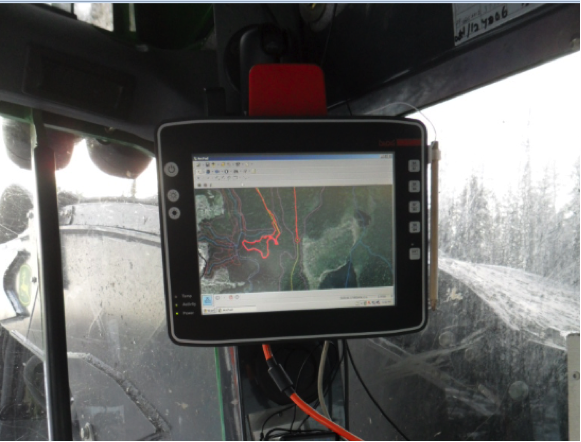
Advanteck Inc. designed and developed a Sub-Meter GPS Navigation System for brush and forest clearing operations. The system utilizes a 10 inch touch screen rugged computer to display a variety of information including digital maps, high-resolution photography and LiDar data. Virtually any information that can be displayed on an office computer can be displayed on our Onboard Navigation System.
On-Board Sub-Meter GPS Navigation System
The system has been in operation since November, 2012 on a variety of 24/7 operations. The system operates in the toughest environments, in steel tracked heavy equipment in forestry and mining operations.
The system is rugged and rated for use in temperatures ranging from to -40°C to +30°C. The system has been in operation on 24/7 hr operations in all seasons since November, 2012. The system operates in the toughest environments in steel tracked heavy equipment in forestry and mining operations.
The monitor is positioned in the upper corner of the operators cab, leaving the operator with a clear view of what’s ahead.
The 10 inch colour touch screen capable of displaying high-resolution imagery at a scale of 1:1,200 or better depending on the resolution of the imagery used. Multiple forms of information can be displayed including LiDar, Digital Terrain Models (DTM). Hydro line LiDar-identified danger trees along hydro right-of-ways which then enables single target-tree removal. Boundary lines are displayed over imagery which permits precise day or night time clearing operations. Regardless of weather conditions, clear skies or stormy weather clearing operations can proceed 24/7.
How Does It Work?
Maps or high-resolution aerial photography are displayed on the 10 inch colour touch screen. Aerial photography can be displayed at a scale of 1:1,200 or better, depending on the resolution of the aerial photography. This means that individual trees are visible to the operator. Multiple forms of information can be over-laid on the map or aerial photograph including clearing boundaries, AutoCAD drawings, LiDar data features, and digital terrain or elevation models.
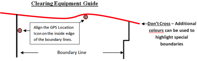
To stay within the boundary, the equipment operator, positions the machine using the GPS Location icon on the monitor alongside the boundary. Virtually any boundary colours or configurations can be overlaid on the map or aerial photo to define different applications.
The System Start-up procedure is simple:
The system is designed for ease of use. can be run in English or French and is user-friendly.
It has been designed so that the operator only need to select 4 buttons (icons) to activate the system. When the day is done the operator simply shuts down the machine, there is no shutdown procedure to follow.
The System Start-up procedure is simple:
• Press the power button.
• Open Project icon.
• Set Scale icon.
• Set Scale Lock/Trackup icon.
Data Collection
Equipment track logs are recorded and archived automatically for data security. Managers can easily and readily download equipment track logs to monitor machine productivity and compliance. Simply insert a USB stick into the monitor and select a dedicated icon, enter a password, select ok and the track logs are automatically transferred to your USB stick.
System Security and Reliability
Reduce Potential Infractions
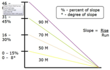
Accuracy
The GPS is accurate to ± 30 cm and has Coast technology, a Hemisphere GPS product which is particularly well suited for challenging GPS-satellite view applications. During temporary loss of differential signal corrections, sub-meter accuracy for up to 40 minutes or more can be achieved. The system provides outstanding performance in environments where maintaining a consistent differential link is difficult. The system provides accurate and minimal position drift.
The GPS antenna is mounted on top of the machine, more than 3 meters above the ground in a protective steel box and is isolated from vibration. This both protects the antenna and positions it in the highest possible location for optima. sky view. The system has been in operations since November, 2012 in a wide range of forest and weather conditions, in the far North without any GPS signal strength issues.
System Security and Reliability
Advanteck deploys a number of security features to improve the reliability and security of the system. We use security or tamper proof fasteners to mount the system to deter the unauthorized removal of the system from the equipment. We employ a security software application that protects the system software from intruders and/or unauthorized entry into the system applications, thereby improving system reliability.
The system has been in operation on a variety of application since November, 2012 and we have not had a single equipment failure to date. The system is installed in steel tracked heavy equipment on 24/7 operations through the summer and winter under extreme operating conditions. The system is operated in rugged environments and by professional operators of all ages ranging from 20 to 60 years of age. They all say that they love the system.
Reduce Potential Infractions
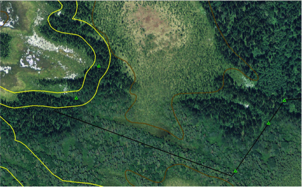
The Ministry of Natural Resources requires that all drainages and streams to be walked in the field and buffered from operations. Regardless if they have been mapped in the planning process or not. Advanteck’s us of high-resolution imagery in forest boundary layout improves the chances that our field staff will 1) be aware of unmapped stream and drainage values before they head to the field, 2) be able to see and follow them with their in-field colour screen tablets (something that is particularly difficult in winter conditions) and 3) delineated them with a track log. See some real cases where streams and drainages were not previously mapped in the planning process (no yellow buffer) but that Advanteck’s protocols, procedures and technologies identified and delineate these unmapped values.
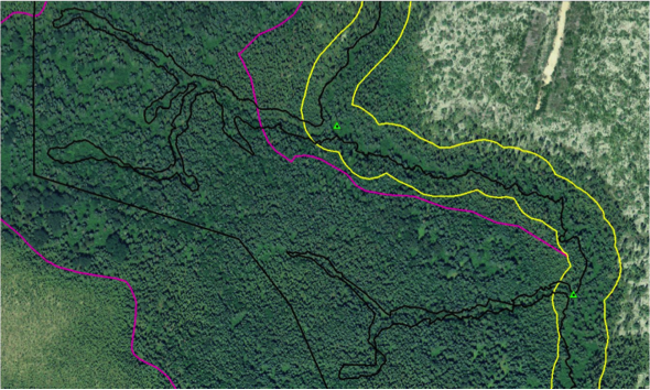
Can you see the drainages in this photo below – Image #1? What if it was in the winter? What if it was in the summer during green up when you can’t see more than 20-30 feet from your position? Advanteck sees unmapped streams and drainages on the high-resolution imagery, highlights them (green triangles) before our field staff visit the forest. This so that our field staff are pre-notified that they need to investigate, walk and delineate these features. We take waypoint and geo-tagged photos of new, unmapped values
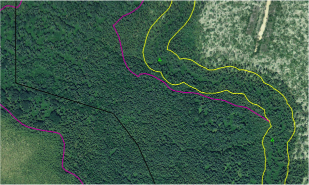
Companies like to avoid stream and drainage crossings when building roads. High-resolution imagery can be used to review the operation and avoid streams and drainages. Advanteck identified streams and drainages in this examples (Image #2) before our field visit.
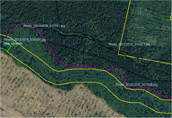
This image (Image #3) shows additional unmapped streams and drainages field technicians identified and delineated ahead of the operation.
Image #4 shows a new unmapped stream (black irregular line) and geo-tagged photos positions at a couple of points.
Forest Surveying Equipment
Forest Surveying Equipment
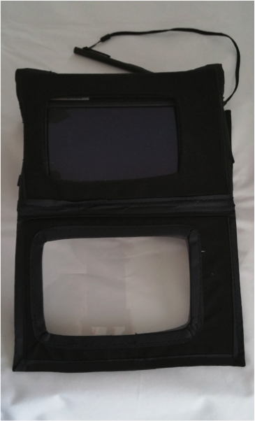
Where sub-meter GPS accuracy is required in the field Advanteck uses military grade rugged tablets. These systems have high-resolution, sunlight-readable 7” colour touch screens and are capable of displaying the same range of information as our navigation system.
Bringing detailed aerial photography, maps and other digital data into the field is an important advantage to our clients. Our surveyors are able to zoom in to a great level of detail, record waypoints and track logs and take geo-tagged photographs with a 5 MP camera.
The full function Windows 7 operating system allows us to load any supporting documentation into the tablet. Operators can reference charts, tables, guidelines or operating procedures in the field. No need to carry clipboards or hard copy documentation. Simply open a reference document on the rugged tablet and search a key word and within an instant the technician has the information he/she needs to complete the job precisely and in compliance with our clients procedures.
Advantages of Onboard GPS Navigation
What’s the Cost?
There are no maintenance or capital cost to the client. Advanteck owns and maintains the systems. We charge by the navigated kilometer, similar to the traditional manual flagging method except it’s less expensive and greatly improves machine productivity. We charge by the parameter boundaries, plus internal features like roads and internal exclusion boundaries.
The system can be installed in the field, on-site and takes approximately 4 hrs per machine. We go to the machine as long as we have pickup access and access to a welder.
Advantages of Onboard GPS Navigation
Working Alone - Improve Safety
In Ontario, the law doesn’t discuss working alone as a distinct issue. However, all employers, managers and supervisors must do “everything that is reasonable under the circumstances: (OHSA, Sec 25) to ensure that their workers have a healthy and safe workplace”. Ensuring that workers working alone are safe is within the scope of the intent of the law. Boundary marking is dangerous work. Advanteck’s system greatly reduces the need for manual boundary flagging and thereby greatly reducing the risk to workers.
Less Kilometers Charged
Under the Ministry of Natural Resources (MNR) managed forests and with Advanteck’s Navigation System only water quality values need to be walked and they are walked with a single pass as opposed to double-pass as required in the manual flagging method. This reduces boundary walking and the kilometer charges to our clients.
Direct Cost Savings
The cost of manual boundary marking has increased over the past 5 years. Advanteck charges less than the current per km rate for boundary control. Line runners charge according to their track logs, not the smooth GIS generated lines. Walked lines result in irregular track log lines which add distance to smooth GIS generated lines. Walked tracklog lines add 10% to 20% distance to the original GIS generated line. Advanteck charges by the GIS generated smooth-line where our Navigation System is used for boundary.
Machine Costs
Navigating with high-resolution imagery significantly reduces unnecessary heavy equipment walking in forestry operations. Simply put, the operators can clearly see ahead and it is easy to identify if there are no merchantable trees ahead. If there is no merchantable trees ahead they don’t go to the area, avoiding unnecessary equipment walking, resulting in dollar savings.
Lost Time
Operators wast a lot of time looking for flagging. With Advanteck’s navigation system there is no need to look for flagging. The high precision of the Navigation System means they know exactly where they are at all times and most importantly, allowing them to stay inside the boundary.
No Capital Cost
Advanteck does not sell systems, we rent and/or provide the systems at a per kilometer rate! We charge a per hour rate to produce the digital colour map(s). The paper copy maps are provided at no cost cost to the client as part of the contract.
No Expertise Required
The Navigation System is simple to use and the operator only needs to turn it on, select the block and set the map scale! Simple and asier than a Garmin.
Improves Efficiency - Measures Progress In All Conditions
For the operator, knowing exactly where he is, opens unlimited opportunities throughout their shift! Operators can measure their progress under all conditions, on-the-fly at any time. With this information they make more efficient operating decisions.
Improves Efficiency - Severe Terrain
In challenging terrain, high-resolution imagery permits the operator to work around obstacles and develop strategies on the fly on how to best approach in any given situation.
Improves Efficiency - Reduced Trespasses
Stream values are not always obvious! What is obvious is that MNR expects all water values to be protected. Advanteck’s process includes a pre-harvest review of the high-resolution imagery and the fact that line markers have high-resolution imagery on their rugged field tablets means that our clients operations are much less likely to get confused and go astray.
Sub-Meter GPS Navigation with Differential Global Positioning System (DGPS)
Advanteck’s system employs Sub-meter GPS accuracy using the WAAS system of satellites and COASTTM technology. COAST permits the GPS receiver to utilize old DGPS correction data for 40 minutes or more without significantly affecting positioning quality. This is particularly useful in heavy forest canopy applications and is exclusive to navigation equipment using COAST technology. Trimble does not have this capability.
Reliability
The equipment Advanteck uses is rugged and has been in operational use since November, 2012 without a single mechanical failure. The equipment has operated on 24/7 operations that have experienced a range of temperatures from -50 ?C to +30 ?C.
System Support
Advanteck has a local presence and provides local support to our clients for our systems and services. Advanteck is led by a professional forester with more than 30 years of experience in operations and planning. Advanteck uses online internet support tools so that we can service clients wherever they are as long as they have access to the internet. Advanteck has extensive experience with ArcGIS and AutoCAD.
User-Friendly
The system is user friendly and is currently used in bilingual operations by operators with virtually no computer experience.
Managing Line Runners
Companies are finding it increasingly difficult to maintain line-running personnel. Advanteck’s navigation system greatly reduces the need for manual boundary flagging. Advanteck will take over this responsibility from our clients. Information is key to getting the job done right.
Equipment Navigation Applications
Advanteck has applied its’ navigation system in the forestry and mining sectors for brush clearing, harvesting operations and individual danger-tree selection along hydro lines. The clearing of boundary lines can be overlaid on top of maps, aerial photography or Digital Surface Models (DSM). The equipment operator is able to zoom into these images and with the Sub-Meter GPS System, navigate within the boundaries to perform the appropriate clearing prescription.
Sub-Meter GPS Navigation System
With ArcGIS we can create aerial photography mosaics, essentially airphoto maps which depict hydro line boundaries, stream buffers and in the case shown below danger-tree LiDar clusters that the operators uses to select out and fell individual trees. The accuracy of the system is such that the operator, day or night can travel hundreds of kilometers, clearing boundaries, avoiding sensitive areas and felling individual danger trees as they are encountered.
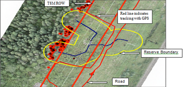
This image shows a screenshot from a monitoring report from a hydro line brushing operation. Seven pieces of heavy equipment were equipped with our Navigation System and charged with maintaining the hydro line right-of-way boundary, staying out of stream reserves and removing LiDar-identified danger-trees from the edge of the right-of-way. The operation was conducted along a 150 km hydro line, in the winter, operating 24/7 over a 3 month period with temperatures as low as -38°C.
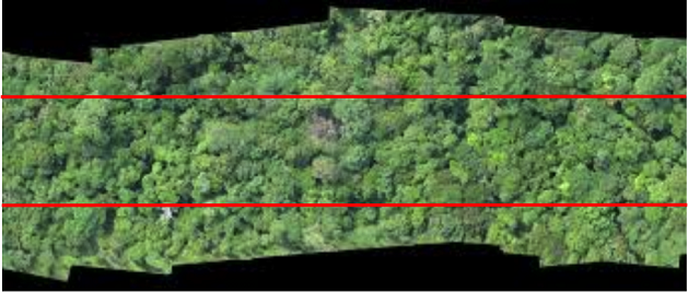
Imagery taken in the summer allows us to identify and avoid streams and drainages. Navigation System operators can readily see these features and buffers thereby reducing the chance of missing them under a blanket of snow.
Geo-referenced ortho-mosaic photographs are used in our Navigation System to accurately control boundary clearing and single tree extraction operations on mine sites, hydro lines and forest operations.
Geo-referenced ortho-mosaic photograph of a hydro line right-of-way (boundary in red).
Source: http://advanteck.ca/gps-navigation/
Magazine
No information