GeoticGraph
Characteristic:
More Details
• user-friendly and intuitive Windows environment (Windows XP to Windows 7)
• trilingual (English, French and Spanish)
• oriented graphical symbols for structural elements (fault, schitosity, joint, etc.)
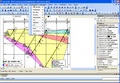
• optimized to create sections drawings in the GeoticCAD VDCL 3D format
• high quality drawings
• functionalities that adapts to all needs
• creation of 3D drawings in DWG and DGN format (AutoCAD and Micro Station software not required)
• 2D drawing formats (JPG, TIF, PNG, EMF, GIF, BMP, WMF, TGA)
• creation of scaled drawing in PDF format
• color codes 100% customizable associated to core descriptions
• possibility to include graphs for the geophysics and assays
• legend texts for creation of legend with GeoticCAD
• integration of drilling core photos
• 3D planning of drillings taking into account the theoretical deviations
• calculate and export the assay or drillings coordinates in text format
• total control over data presentation including bar charts
• conversion between the 3 coordinate systems (imperial and/or metric)
• section creation wizard