Geotic Inc.
GeoticCAD
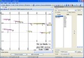
Characteristic:
More details
• user-friendly and intuitive environment under Windows (XP to Windows 7)
• user-friendly and intuitive environment under Windows (XP to Windows 7)
• trilingual (English, French, Spanish)
• optimized to use sections drawings in the GeoticGraph VDML 3D format
• simple movement between the 3 coordinate systems (World, Measure and Plot)
• export to the usual Image formats (TIF, PNG, JPG, EMF, GIF, BMP, WMF, TGA)
• export to PDF format respecting a scale
• export to DWG and DGN formats (AutoCAD and Micro Station software and not required)
• powerful geometrical measuring and drawing edition tools
• Insertion of legends, graphic scales, and wind rose
• import of various 2D and 3D formats
• integration of the drilling core photos
• intelligent tools allowing the follow-ups and the evolution of mining projects•
• automatic interpretation of the topography and the bedrock
Featured Products