Timbercraft Consultation Inc.
Aggregate Services
• Complete aggregate permit applications
• Certified under the Aggregates Resources Act to prepare Class A & B licenses
• GPS surveying (sub centimeter & meter accuracy)
• Water table establishment
• Well installation and monitoring
• Drilling services
• Level 1 & 2 technical reports
• Boundary layout
• Exploration for surficial and bedrock resources
• Stockpile & pre-blast volume measurement calculations
• Contour mapping
• Stake mining claims
• Compliance assessment reports
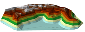
Blast Map – gauge quarry size before and after blast
Salt Dome Volume – calculate in-dome stockpile volume
Stockpile Map – illustrate layout and inventory
Stone Dust Volume – calculate challenging volumes
Examples Of Our Mapping Capabilities:
Blast Map – gauge quarry size before and after blast
Salt Dome Volume – calculate in-dome stockpile volume
Stockpile Map – illustrate layout and inventory
Stone Dust Volume – calculate challenging volumes
Timbercraft has completed 350+ aggregate license and permit applicationsincluding; sub-meter GPS field data collection, detailed site plans, detailed site plan notes, Summary Statements and Natural Environment Level 1 and 2 reports. These include 150+ A Licenses, 200 B Licenses and 40-50 permits.
We were responsible for the identification of natural features including: habitat of endangered species, significant wetlands, fish habitat, significant wildlife habitat and significant areas of natural and scientific interest. We completed drilling programs for water table determination, and monitoring of well installations.
Source: http://timbercraftconsultation.com/aggregate-services/
Magazine
No information